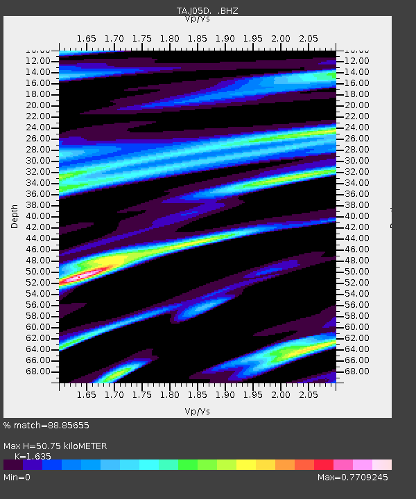
J05D Fort Rock, OR, USA - Earthquake Result Viewer
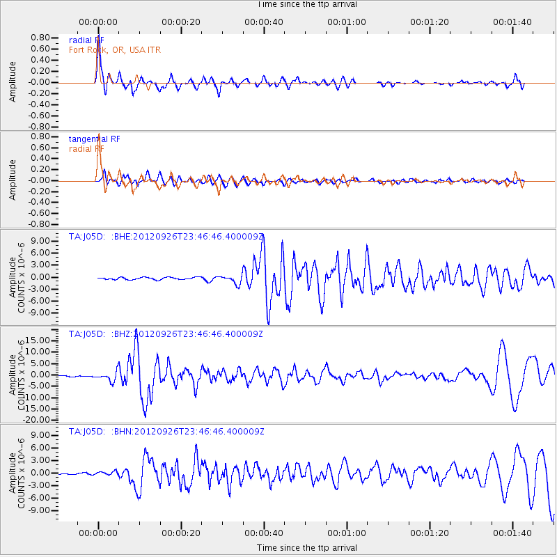
Earthquake location: Andreanof Islands, Aleutian Is.
Earthquake latitude/longitude: 51.6/-178.3
Earthquake time(UTC): 2012/09/26 (270) 23:39:55 GMT
Earthquake Depth: 16 km
Earthquake Magnitude: 6.3 MB, 6.5 MS, 6.4 MW, 6.4 MW
Earthquake Catalog/Contributor: WHDF/NEIC
Network: TA USArray Transportable Network (new EarthScope stations)
Station: J05D Fort Rock, OR, USA
Lat/Lon: 43.28 N/121.23 W
Elevation: 1541 m
Distance: 38.6 deg
Az: 79.297 deg
Baz: 302.924 deg
Ray Param: 0.075460345
Estimated Moho Depth: 50.75 km
Estimated Crust Vp/Vs: 1.63
Assumed Crust Vp: 6.597 km/s
Estimated Crust Vs: 4.035 km/s
Estimated Crust Poisson's Ratio: 0.20
Radial Match: 88.85655 %
Radial Bump: 400
Transverse Match: 79.26236 %
Transverse Bump: 400
SOD ConfigId: 478790
Insert Time: 2013-02-22 23:18:09.416 +0000
GWidth: 2.5
Max Bumps: 400
Tol: 0.001

Signal To Noise

ChannelStoNSTALTA
TA:J05D: :BHZ:20120926T23:46:46.400009Z9.1706622.1338424E-62.3268139E-7
TA:J05D: :BHN:20120926T23:46:46.400009Z1.4261723.9854697E-72.7945225E-7
TA:J05D: :BHE:20120926T23:46:46.400009Z4.0235531.1075745E-62.7527278E-7
Arrivals
Ps5.3 SECOND
PpPs19 SECOND
PsPs/PpSs24 SECOND