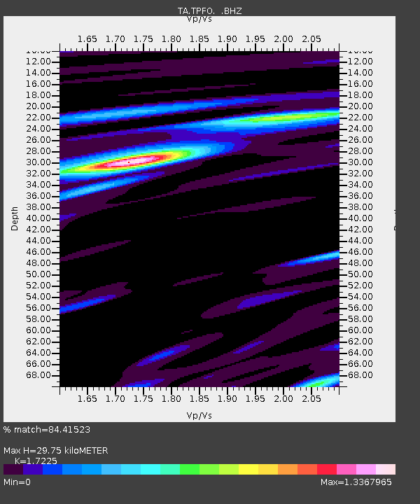
TPFO Pinon Flats, CA, USA - Earthquake Result Viewer
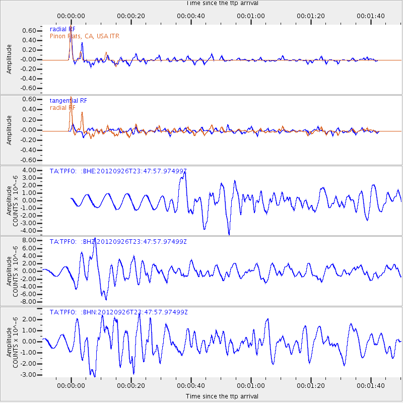
Earthquake location: Andreanof Islands, Aleutian Is.
Earthquake latitude/longitude: 51.6/-178.3
Earthquake time(UTC): 2012/09/26 (270) 23:39:55 GMT
Earthquake Depth: 16 km
Earthquake Magnitude: 6.3 MB, 6.5 MS, 6.4 MW, 6.4 MW
Earthquake Catalog/Contributor: WHDF/NEIC
Network: TA USArray Transportable Network (new EarthScope stations)
Station: TPFO Pinon Flats, CA, USA
Lat/Lon: 33.61 N/116.45 W
Elevation: 1275 m
Distance: 47.4 deg
Az: 87.212 deg
Baz: 311.704 deg
Ray Param: 0.069967225
Estimated Moho Depth: 29.75 km
Estimated Crust Vp/Vs: 1.72
Assumed Crust Vp: 6.264 km/s
Estimated Crust Vs: 3.636 km/s
Estimated Crust Poisson's Ratio: 0.25
Radial Match: 84.41523 %
Radial Bump: 364
Transverse Match: 77.40455 %
Transverse Bump: 400
SOD ConfigId: 478790
Insert Time: 2013-02-22 23:18:43.089 +0000
GWidth: 2.5
Max Bumps: 400
Tol: 0.001

Signal To Noise

ChannelStoNSTALTA
TA:TPFO: :BHZ:20120926T23:47:57.97499Z4.477662.802438E-66.258711E-7
TA:TPFO: :BHN:20120926T23:47:57.97499Z3.73955251.1238051E-63.005186E-7
TA:TPFO: :BHE:20120926T23:47:57.97499Z1.09204487.2715335E-76.65864E-7
Arrivals
Ps3.6 SECOND
PpPs12 SECOND
PsPs/PpSs16 SECOND