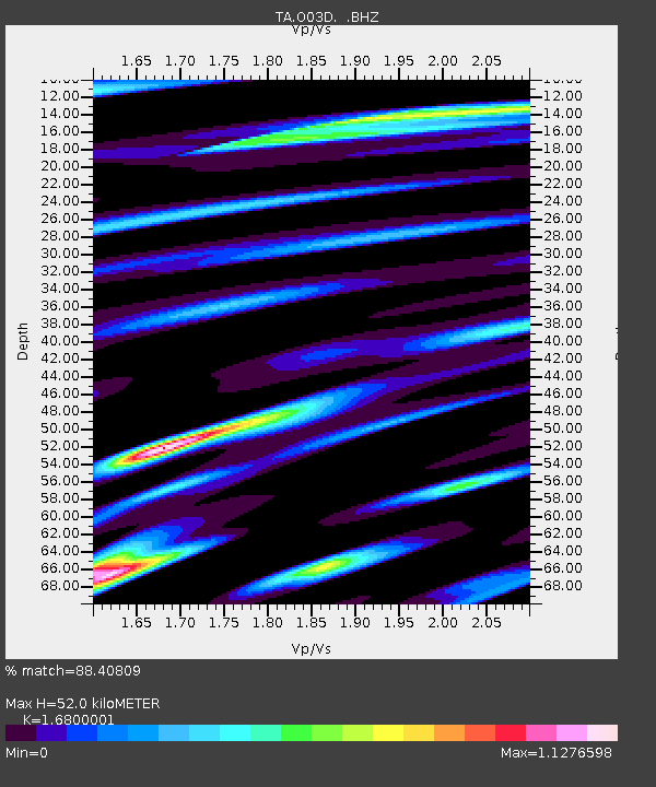
O03D Paynes Creek, CA, USA - Earthquake Result Viewer
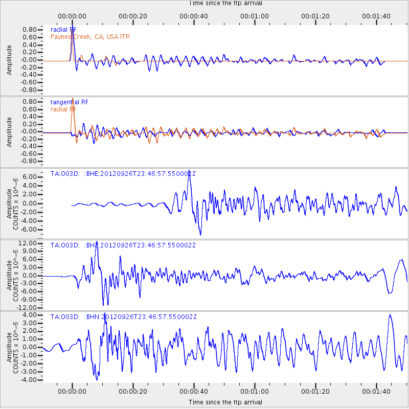
Earthquake location: Andreanof Islands, Aleutian Is.
Earthquake latitude/longitude: 51.6/-178.3
Earthquake time(UTC): 2012/09/26 (270) 23:39:55 GMT
Earthquake Depth: 16 km
Earthquake Magnitude: 6.3 MB, 6.5 MS, 6.4 MW, 6.4 MW
Earthquake Catalog/Contributor: WHDF/NEIC
Network: TA USArray Transportable Network (new EarthScope stations)
Station: O03D Paynes Creek, CA, USA
Lat/Lon: 40.29 N/121.80 W
Elevation: 968 m
Distance: 39.9 deg
Az: 83.572 deg
Baz: 305.859 deg
Ray Param: 0.07468007
Estimated Moho Depth: 52.0 km
Estimated Crust Vp/Vs: 1.68
Assumed Crust Vp: 6.566 km/s
Estimated Crust Vs: 3.908 km/s
Estimated Crust Poisson's Ratio: 0.23
Radial Match: 88.40809 %
Radial Bump: 400
Transverse Match: 72.963326 %
Transverse Bump: 400
SOD ConfigId: 478790
Insert Time: 2013-02-22 23:18:58.744 +0000
GWidth: 2.5
Max Bumps: 400
Tol: 0.001

Signal To Noise

ChannelStoNSTALTA
TA:O03D: :BHZ:20120926T23:46:57.550002Z15.492061.8074189E-61.16667444E-7
TA:O03D: :BHN:20120926T23:46:57.550002Z3.22637418.153632E-72.527181E-7
TA:O03D: :BHE:20120926T23:46:57.550002Z5.57025431.2738417E-62.2868645E-7
Arrivals
Ps5.8 SECOND
PpPs20 SECOND
PsPs/PpSs25 SECOND