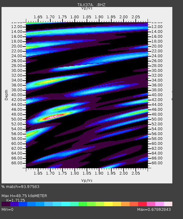
K37A Belmond, IA, USA - Earthquake Result Viewer

Earthquake location: Andreanof Islands, Aleutian Is.
Earthquake latitude/longitude: 51.6/-178.3
Earthquake time(UTC): 2012/09/26 (270) 23:39:55 GMT
Earthquake Depth: 16 km
Earthquake Magnitude: 6.3 MB, 6.5 MS, 6.4 MW, 6.4 MW
Earthquake Catalog/Contributor: WHDF/NEIC
Network: TA USArray Transportable Network (new EarthScope stations)
Station: K37A Belmond, IA, USA
Lat/Lon: 42.77 N/93.64 W
Elevation: 365 m
Distance: 55.1 deg
Az: 63.319 deg
Baz: 310.806 deg
Ray Param: 0.06497503
Estimated Moho Depth: 48.75 km
Estimated Crust Vp/Vs: 1.71
Assumed Crust Vp: 6.53 km/s
Estimated Crust Vs: 3.813 km/s
Estimated Crust Poisson's Ratio: 0.24
Radial Match: 93.97583 %
Radial Bump: 400
Transverse Match: 62.5772 %
Transverse Bump: 400
SOD ConfigId: 478790
Insert Time: 2013-02-22 23:19:20.914 +0000
GWidth: 2.5
Max Bumps: 400
Tol: 0.001

Signal To Noise

ChannelStoNSTALTA
TA:K37A: :BHZ:20120926T23:48:55.575027Z13.46412851.2526298E-69.303459E-8
TA:K37A: :BHN:20120926T23:48:55.575027Z3.56805784.1036566E-71.15010934E-7
TA:K37A: :BHE:20120926T23:48:55.575027Z3.12372354.3427312E-71.3902418E-7
Arrivals
Ps5.6 SECOND
PpPs19 SECOND
PsPs/PpSs25 SECOND