You are here: Home > Network List > GS - US Geological Survey Networks Stations List
> Station DEC09 Decatur Surface Seismic Site, Decatur, IL, USA > Earthquake Result Viewer
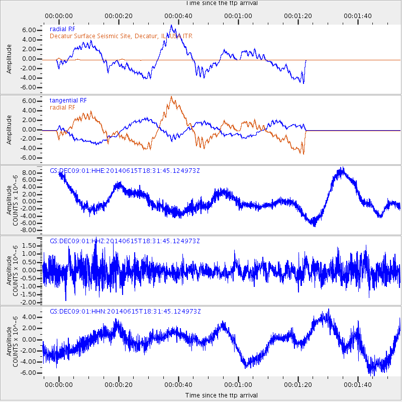
DEC09 Decatur Surface Seismic Site, Decatur, IL, USA - Earthquake Result Viewer
*The percent match for this event was below the threshold and hence no stack was calculated.
| Earthquake location: |
Near East Coast Of Honshu, Japan |
| Earthquake latitude/longitude: |
36.6/141.8 |
| Earthquake time(UTC): |
2014/06/15 (166) 18:19:15 GMT |
| Earthquake Depth: |
23 km |
| Earthquake Magnitude: |
5.7 MB |
| Earthquake Catalog/Contributor: |
NEIC PDE/NEIC COMCAT |
|
| Network: |
GS US Geological Survey Networks |
| Station: |
DEC09 Decatur Surface Seismic Site, Decatur, IL, USA |
| Lat/Lon: |
39.87 N/88.92 W |
| Elevation: |
207 m |
|
| Distance: |
90.7 deg |
| Az: |
36.556 deg |
| Baz: |
321.503 deg |
| Ray Param: |
$rayparam |
*The percent match for this event was below the threshold and hence was not used in the summary stack. |
|
| Radial Match: |
46.17644 % |
| Radial Bump: |
379 |
| Transverse Match: |
55.331135 % |
| Transverse Bump: |
400 |
| SOD ConfigId: |
3390531 |
| Insert Time: |
2019-04-12 06:50:56.285 +0000 |
| GWidth: |
2.5 |
| Max Bumps: |
400 |
| Tol: |
0.001 |
|
Signal To Noise
| Channel | StoN | STA | LTA |
| GS:DEC09:01:HHZ:20140615T18:31:45.124973Z | 1.5086569 | 5.5936056E-7 | 3.7076725E-7 |
| GS:DEC09:01:HHN:20140615T18:31:45.124973Z | 1.0231631 | 2.4976493E-6 | 2.4411058E-6 |
| GS:DEC09:01:HHE:20140615T18:31:45.124973Z | 0.836923 | 2.4877522E-6 | 2.9724984E-6 |
| Arrivals |
| Ps | |
| PpPs | |
| PsPs/PpSs | |


