You are here: Home > Network List > GS - US Geological Survey Networks Stations List
> Station KAN10 Keim Farm > Earthquake Result Viewer
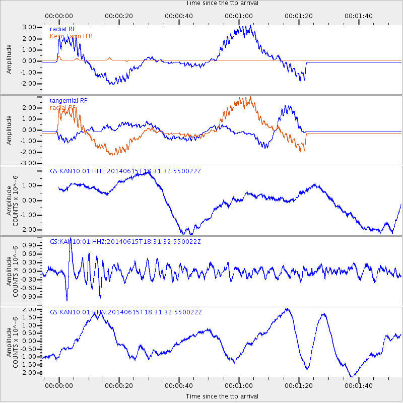
KAN10 Keim Farm - Earthquake Result Viewer
*The percent match for this event was below the threshold and hence no stack was calculated.
| Earthquake location: |
Near East Coast Of Honshu, Japan |
| Earthquake latitude/longitude: |
36.6/141.8 |
| Earthquake time(UTC): |
2014/06/15 (166) 18:19:15 GMT |
| Earthquake Depth: |
23 km |
| Earthquake Magnitude: |
5.7 MB |
| Earthquake Catalog/Contributor: |
NEIC PDE/NEIC COMCAT |
|
| Network: |
GS US Geological Survey Networks |
| Station: |
KAN10 Keim Farm |
| Lat/Lon: |
37.12 N/98.10 W |
| Elevation: |
417 m |
|
| Distance: |
88.0 deg |
| Az: |
43.768 deg |
| Baz: |
315.887 deg |
| Ray Param: |
$rayparam |
*The percent match for this event was below the threshold and hence was not used in the summary stack. |
|
| Radial Match: |
71.549614 % |
| Radial Bump: |
400 |
| Transverse Match: |
48.162495 % |
| Transverse Bump: |
287 |
| SOD ConfigId: |
3390531 |
| Insert Time: |
2019-04-12 06:50:58.007 +0000 |
| GWidth: |
2.5 |
| Max Bumps: |
400 |
| Tol: |
0.001 |
|
Signal To Noise
| Channel | StoN | STA | LTA |
| GS:KAN10:01:HHZ:20140615T18:31:32.550022Z | 6.3714094 | 5.029385E-7 | 7.893677E-8 |
| GS:KAN10:01:HHN:20140615T18:31:32.550022Z | 0.5519272 | 6.9329315E-7 | 1.2561314E-6 |
| GS:KAN10:01:HHE:20140615T18:31:32.550022Z | 2.0124655 | 6.12351E-7 | 3.04279E-7 |
| Arrivals |
| Ps | |
| PpPs | |
| PsPs/PpSs | |


