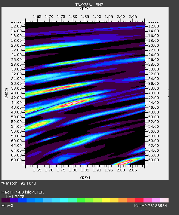
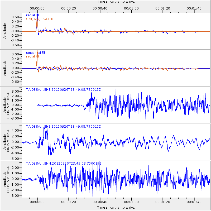
O38A Galt, MO, USA - Earthquake Result Viewer

Earthquake location: Andreanof Islands, Aleutian Is.
Earthquake latitude/longitude: 51.6/-178.3
Earthquake time(UTC): 2012/09/26 (270) 23:39:55 GMT
Earthquake Depth: 16 km
Earthquake Magnitude: 6.3 MB, 6.5 MS, 6.4 MW, 6.4 MW
Earthquake Catalog/Contributor: WHDF/NEIC
Network: TA USArray Transportable Network (new EarthScope stations)
Station: O38A Galt, MO, USA
Lat/Lon: 40.12 N/93.47 W
Elevation: 266 m
Distance: 57.0 deg
Az: 65.606 deg
Baz: 312.192 deg
Ray Param: 0.0637684
Estimated Moho Depth: 44.0 km
Estimated Crust Vp/Vs: 1.80
Assumed Crust Vp: 6.498 km/s
Estimated Crust Vs: 3.615 km/s
Estimated Crust Poisson's Ratio: 0.28
Radial Match: 92.1043 %
Radial Bump: 400
Transverse Match: 57.94713 %
Transverse Bump: 400
SOD ConfigId: 478790
Insert Time: 2013-02-22 23:20:02.390 +0000
GWidth: 2.5
Max Bumps: 400
Tol: 0.001

Signal To Noise

ChannelStoNSTALTA
TA:O38A: :BHZ:20120926T23:49:08.750015Z17.5868722.0727116E-61.17855606E-7
TA:O38A: :BHN:20120926T23:49:08.750015Z5.5890627.1446584E-71.2783288E-7
TA:O38A: :BHE:20120926T23:49:08.750015Z9.4848319.2677107E-79.771087E-8
Arrivals
Ps5.7 SECOND
PpPs18 SECOND
PsPs/PpSs24 SECOND