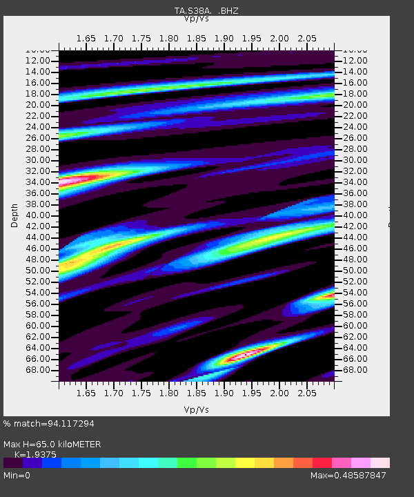
S38A Stockton, MO, USA - Earthquake Result Viewer

Earthquake location: Andreanof Islands, Aleutian Is.
Earthquake latitude/longitude: 51.6/-178.3
Earthquake time(UTC): 2012/09/26 (270) 23:39:55 GMT
Earthquake Depth: 16 km
Earthquake Magnitude: 6.3 MB, 6.5 MS, 6.4 MW, 6.4 MW
Earthquake Catalog/Contributor: WHDF/NEIC
Network: TA USArray Transportable Network (new EarthScope stations)
Station: S38A Stockton, MO, USA
Lat/Lon: 37.63 N/93.91 W
Elevation: 294 m
Distance: 58.4 deg
Az: 68.041 deg
Baz: 313.221 deg
Ray Param: 0.06283973
Estimated Moho Depth: 65.0 km
Estimated Crust Vp/Vs: 1.94
Assumed Crust Vp: 6.53 km/s
Estimated Crust Vs: 3.371 km/s
Estimated Crust Poisson's Ratio: 0.32
Radial Match: 94.117294 %
Radial Bump: 323
Transverse Match: 75.16556 %
Transverse Bump: 400
SOD ConfigId: 478790
Insert Time: 2013-02-22 23:20:52.161 +0000
GWidth: 2.5
Max Bumps: 400
Tol: 0.001

Signal To Noise

ChannelStoNSTALTA
TA:S38A: :BHZ:20120926T23:49:18.825027Z13.1535481.7313937E-61.316294E-7
TA:S38A: :BHN:20120926T23:49:18.825027Z5.54288435.5579295E-71.00271436E-7
TA:S38A: :BHE:20120926T23:49:18.825027Z7.0766345.794266E-78.187885E-8
Arrivals
Ps9.8 SECOND
PpPs28 SECOND
PsPs/PpSs38 SECOND