You are here: Home > Network List > TA - USArray Transportable Network (new EarthScope stations) Stations List
> Station W40A Ferguson Farm, Pottsville, AR, USA > Earthquake Result Viewer
W40A Ferguson Farm, Pottsville, AR, USA - Earthquake Result Viewer
| Earthquake location: |
Andreanof Islands, Aleutian Is. |
| Earthquake latitude/longitude: |
51.6/-178.3 |
| Earthquake time(UTC): |
2012/09/26 (270) 23:39:55 GMT |
| Earthquake Depth: |
16 km |
| Earthquake Magnitude: |
6.3 MB, 6.5 MS, 6.4 MW, 6.4 MW |
| Earthquake Catalog/Contributor: |
WHDF/NEIC |
|
| Network: |
TA USArray Transportable Network (new EarthScope stations) |
| Station: |
W40A Ferguson Farm, Pottsville, AR, USA |
| Lat/Lon: |
35.19 N/93.07 W |
| Elevation: |
108 m |
|
| Distance: |
60.6 deg |
| Az: |
69.533 deg |
| Baz: |
314.474 deg |
| Ray Param: |
0.061413296 |
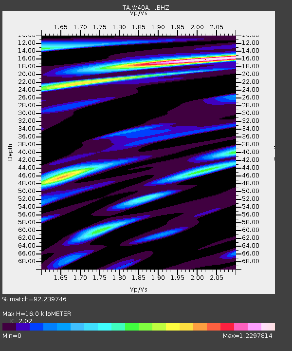
| Estimated Moho Depth: |
16.0 km |
| Estimated Crust Vp/Vs: |
2.02 |
| Assumed Crust Vp: |
6.498 km/s |
| Estimated Crust Vs: |
3.217 km/s |
| Estimated Crust Poisson's Ratio: |
0.34 |
|
| Radial Match: |
92.239746 % |
| Radial Bump: |
400 |
| Transverse Match: |
88.563866 % |
| Transverse Bump: |
400 |
| SOD ConfigId: |
478790 |
| Insert Time: |
2013-02-22 23:20:57.270 +0000 |
| GWidth: |
2.5 |
| Max Bumps: |
400 |
| Tol: |
0.001 |
|
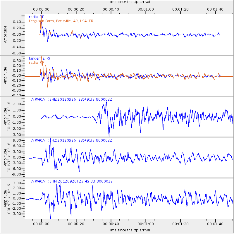
Signal To Noise
| Channel | StoN | STA | LTA |
| TA:W40A: :BHZ:20120926T23:49:33.800002Z | 16.726564 | 2.4088636E-6 | 1.4401425E-7 |
| TA:W40A: :BHN:20120926T23:49:33.800002Z | 8.121883 | 7.6746306E-7 | 9.4493245E-8 |
| TA:W40A: :BHE:20120926T23:49:33.800002Z | 3.3053095 | 4.861499E-7 | 1.470815E-7 |
| Arrivals |
| Ps | 2.6 SECOND |
| PpPs | 7.1 SECOND |
| PsPs/PpSs | 9.8 SECOND |


