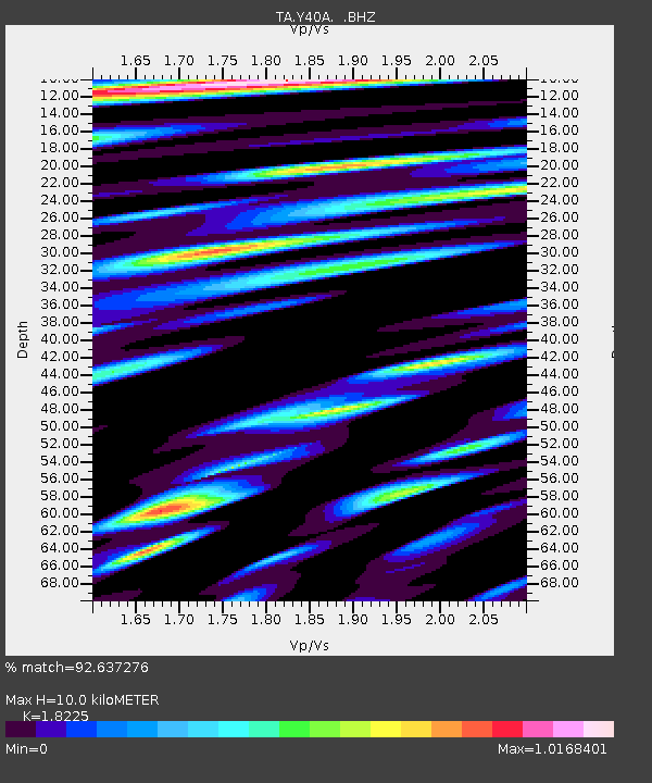
Y40A Okolona, AR, USA - Earthquake Result Viewer
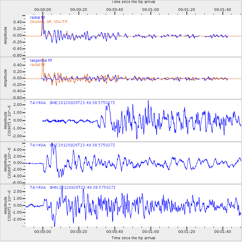
Earthquake location: Andreanof Islands, Aleutian Is.
Earthquake latitude/longitude: 51.6/-178.3
Earthquake time(UTC): 2012/09/26 (270) 23:39:55 GMT
Earthquake Depth: 16 km
Earthquake Magnitude: 6.3 MB, 6.5 MS, 6.4 MW, 6.4 MW
Earthquake Catalog/Contributor: WHDF/NEIC
Network: TA USArray Transportable Network (new EarthScope stations)
Station: Y40A Okolona, AR, USA
Lat/Lon: 34.01 N/93.28 W
Elevation: 117 m
Distance: 61.3 deg
Az: 70.63 deg
Baz: 314.888 deg
Ray Param: 0.060947757
Estimated Moho Depth: 10.0 km
Estimated Crust Vp/Vs: 1.82
Assumed Crust Vp: 6.498 km/s
Estimated Crust Vs: 3.565 km/s
Estimated Crust Poisson's Ratio: 0.28
Radial Match: 92.637276 %
Radial Bump: 400
Transverse Match: 81.70943 %
Transverse Bump: 400
SOD ConfigId: 478790
Insert Time: 2013-02-22 23:21:33.652 +0000
GWidth: 2.5
Max Bumps: 400
Tol: 0.001

Signal To Noise

ChannelStoNSTALTA
TA:Y40A: :BHZ:20120926T23:49:38.575027Z12.1087031.5540953E-61.2834533E-7
TA:Y40A: :BHN:20120926T23:49:38.575027Z4.59051474.9694813E-71.0825543E-7
TA:Y40A: :BHE:20120926T23:49:38.575027Z4.9145814.875541E-79.9205636E-8
Arrivals
Ps1.3 SECOND
PpPs4.2 SECOND
PsPs/PpSs5.5 SECOND