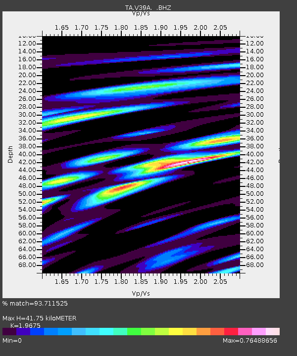
V39A Pettigrew, AR, USA - Earthquake Result Viewer

Earthquake location: Andreanof Islands, Aleutian Is.
Earthquake latitude/longitude: 51.6/-178.3
Earthquake time(UTC): 2012/09/26 (270) 23:39:55 GMT
Earthquake Depth: 16 km
Earthquake Magnitude: 6.3 MB, 6.5 MS, 6.4 MW, 6.4 MW
Earthquake Catalog/Contributor: WHDF/NEIC
Network: TA USArray Transportable Network (new EarthScope stations)
Station: V39A Pettigrew, AR, USA
Lat/Lon: 35.84 N/93.64 W
Elevation: 744 m
Distance: 59.8 deg
Az: 69.378 deg
Baz: 314.064 deg
Ray Param: 0.061929915
Estimated Moho Depth: 41.75 km
Estimated Crust Vp/Vs: 1.97
Assumed Crust Vp: 6.498 km/s
Estimated Crust Vs: 3.302 km/s
Estimated Crust Poisson's Ratio: 0.33
Radial Match: 93.711525 %
Radial Bump: 400
Transverse Match: 73.70921 %
Transverse Bump: 400
SOD ConfigId: 478790
Insert Time: 2013-02-22 23:21:38.568 +0000
GWidth: 2.5
Max Bumps: 400
Tol: 0.001

Signal To Noise

ChannelStoNSTALTA
TA:V39A: :BHZ:20120926T23:49:28.425002Z16.1254352.0337384E-61.2611991E-7
TA:V39A: :BHN:20120926T23:49:28.425002Z7.7832627.9098044E-71.0162583E-7
TA:V39A: :BHE:20120926T23:49:28.425002Z9.5675046.674425E-76.9761406E-8
Arrivals
Ps6.5 SECOND
PpPs18 SECOND
PsPs/PpSs25 SECOND