You are here: Home > Network List > TA - USArray Transportable Network (new EarthScope stations) Stations List
> Station 143A Socs Landing, Pioneer, LA, USA > Earthquake Result Viewer
143A Socs Landing, Pioneer, LA, USA - Earthquake Result Viewer
| Earthquake location: |
Andreanof Islands, Aleutian Is. |
| Earthquake latitude/longitude: |
51.6/-178.3 |
| Earthquake time(UTC): |
2012/09/26 (270) 23:39:55 GMT |
| Earthquake Depth: |
16 km |
| Earthquake Magnitude: |
6.3 MB, 6.5 MS, 6.4 MW, 6.4 MW |
| Earthquake Catalog/Contributor: |
WHDF/NEIC |
|
| Network: |
TA USArray Transportable Network (new EarthScope stations) |
| Station: |
143A Socs Landing, Pioneer, LA, USA |
| Lat/Lon: |
32.70 N/91.40 W |
| Elevation: |
30 m |
|
| Distance: |
63.3 deg |
| Az: |
70.405 deg |
| Baz: |
315.81 deg |
| Ray Param: |
0.059631318 |
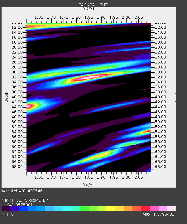
| Estimated Moho Depth: |
31.75 km |
| Estimated Crust Vp/Vs: |
1.86 |
| Assumed Crust Vp: |
6.201 km/s |
| Estimated Crust Vs: |
3.339 km/s |
| Estimated Crust Poisson's Ratio: |
0.30 |
|
| Radial Match: |
91.492546 % |
| Radial Bump: |
330 |
| Transverse Match: |
82.29419 % |
| Transverse Bump: |
400 |
| SOD ConfigId: |
478790 |
| Insert Time: |
2013-02-22 23:22:44.941 +0000 |
| GWidth: |
2.5 |
| Max Bumps: |
400 |
| Tol: |
0.001 |
|
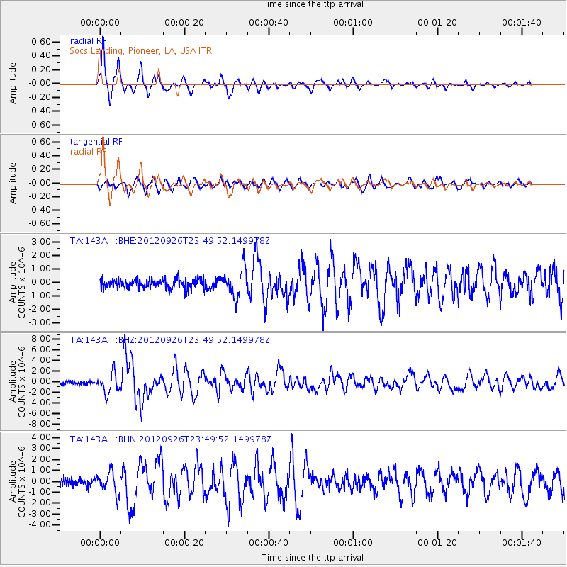
Signal To Noise
| Channel | StoN | STA | LTA |
| TA:143A: :BHZ:20120926T23:49:52.149978Z | 8.317365 | 1.8788187E-6 | 2.2589111E-7 |
| TA:143A: :BHN:20120926T23:49:52.149978Z | 2.8344886 | 9.553953E-7 | 3.370609E-7 |
| TA:143A: :BHE:20120926T23:49:52.149978Z | 3.1775243 | 1.0522306E-6 | 3.3114793E-7 |
| Arrivals |
| Ps | 4.6 SECOND |
| PpPs | 14 SECOND |
| PsPs/PpSs | 19 SECOND |


