You are here: Home > Network List > G - GEOSCOPE Stations List
> Station WUS Wushi, Xinjiang Uygur, China > Earthquake Result Viewer
WUS Wushi, Xinjiang Uygur, China - Earthquake Result Viewer
| Earthquake location: |
Near Coast Of Northern Calif. |
| Earthquake latitude/longitude: |
40.4/-124.3 |
| Earthquake time(UTC): |
1992/04/25 (116) 18:06:04 GMT |
| Earthquake Depth: |
15 km |
| Earthquake Magnitude: |
6.4 MB, 7.1 MS |
| Earthquake Catalog/Contributor: |
WHDF/NEIC |
|
| Network: |
G GEOSCOPE |
| Station: |
WUS Wushi, Xinjiang Uygur, China |
| Lat/Lon: |
41.20 N/79.22 E |
| Elevation: |
1457 m |
|
| Distance: |
96.0 deg |
| Az: |
342.362 deg |
| Baz: |
17.865 deg |
| Ray Param: |
0.040618964 |
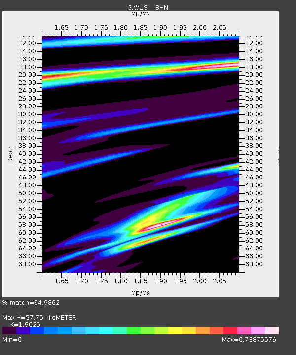
| Estimated Moho Depth: |
57.75 km |
| Estimated Crust Vp/Vs: |
1.90 |
| Assumed Crust Vp: |
6.353 km/s |
| Estimated Crust Vs: |
3.339 km/s |
| Estimated Crust Poisson's Ratio: |
0.31 |
|
| Radial Match: |
94.9862 % |
| Radial Bump: |
400 |
| Transverse Match: |
92.05566 % |
| Transverse Bump: |
400 |
| SOD ConfigId: |
16938 |
| Insert Time: |
2010-02-27 00:49:11.840 +0000 |
| GWidth: |
2.5 |
| Max Bumps: |
400 |
| Tol: |
0.001 |
|
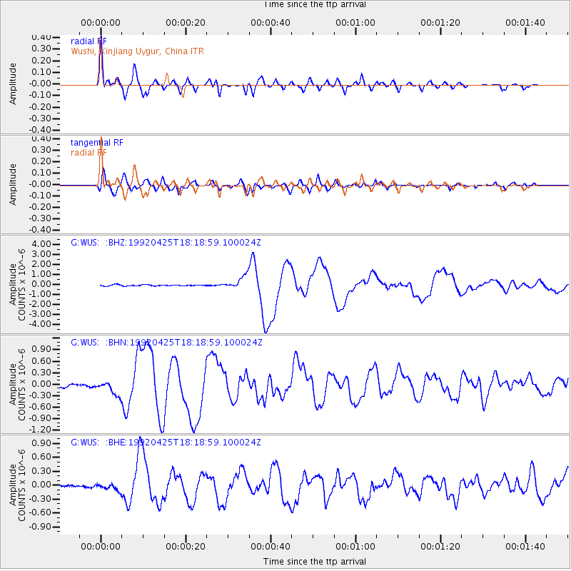
Signal To Noise
| Channel | StoN | STA | LTA |
| G:WUS: :BHN:19920425T18:18:59.100024Z | 4.1948 | 2.0270319E-7 | 4.832249E-8 |
| G:WUS: :BHE:19920425T18:18:59.100024Z | 2.086028 | 7.595001E-8 | 3.640891E-8 |
| G:WUS: :BHZ:19920425T18:18:59.100024Z | 11.842074 | 6.805979E-7 | 5.7472864E-8 |
| Arrivals |
| Ps | 8.4 SECOND |
| PpPs | 26 SECOND |
| PsPs/PpSs | 34 SECOND |


