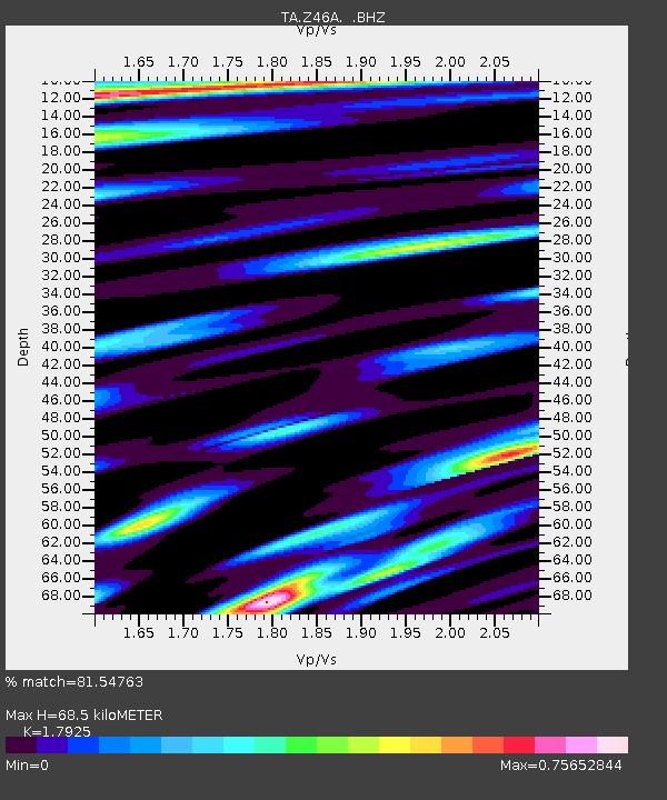
Z46A Louisville, MS, USA - Earthquake Result Viewer
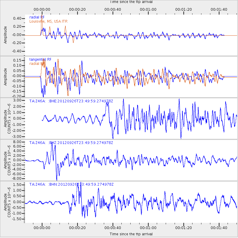
Earthquake location: Andreanof Islands, Aleutian Is.
Earthquake latitude/longitude: 51.6/-178.3
Earthquake time(UTC): 2012/09/26 (270) 23:39:55 GMT
Earthquake Depth: 16 km
Earthquake Magnitude: 6.3 MB, 6.5 MS, 6.4 MW, 6.4 MW
Earthquake Catalog/Contributor: WHDF/NEIC
Network: TA USArray Transportable Network (new EarthScope stations)
Station: Z46A Louisville, MS, USA
Lat/Lon: 33.19 N/88.94 W
Elevation: 125 m
Distance: 64.4 deg
Az: 68.367 deg
Baz: 316.246 deg
Ray Param: 0.058920853
Estimated Moho Depth: 68.5 km
Estimated Crust Vp/Vs: 1.79
Assumed Crust Vp: 6.201 km/s
Estimated Crust Vs: 3.46 km/s
Estimated Crust Poisson's Ratio: 0.27
Radial Match: 81.54763 %
Radial Bump: 400
Transverse Match: 80.71175 %
Transverse Bump: 376
SOD ConfigId: 478790
Insert Time: 2013-02-22 23:26:58.715 +0000
GWidth: 2.5
Max Bumps: 400
Tol: 0.001

Signal To Noise

ChannelStoNSTALTA
TA:Z46A: :BHZ:20120926T23:49:59.274978Z10.4348071.6721821E-61.6025042E-7
TA:Z46A: :BHN:20120926T23:49:59.274978Z0.934675756.46312E-86.914826E-8
TA:Z46A: :BHE:20120926T23:49:59.274978Z1.39153524.9185013E-73.5345863E-7
Arrivals
Ps9.1 SECOND
PpPs30 SECOND
PsPs/PpSs39 SECOND