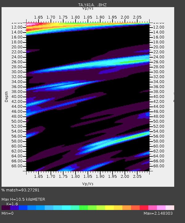
Y41A Eaglette Bearden, AR, USA - Earthquake Result Viewer

Earthquake location: Andreanof Islands, Aleutian Is.
Earthquake latitude/longitude: 51.6/-178.3
Earthquake time(UTC): 2012/09/26 (270) 23:39:55 GMT
Earthquake Depth: 16 km
Earthquake Magnitude: 6.3 MB, 6.5 MS, 6.4 MW, 6.4 MW
Earthquake Catalog/Contributor: WHDF/NEIC
Network: TA USArray Transportable Network (new EarthScope stations)
Station: Y41A Eaglette Bearden, AR, USA
Lat/Lon: 33.88 N/92.61 W
Elevation: 99 m
Distance: 61.8 deg
Az: 70.289 deg
Baz: 315.097 deg
Ray Param: 0.060638666
Estimated Moho Depth: 10.5 km
Estimated Crust Vp/Vs: 1.60
Assumed Crust Vp: 6.245 km/s
Estimated Crust Vs: 3.903 km/s
Estimated Crust Poisson's Ratio: 0.18
Radial Match: 93.27291 %
Radial Bump: 336
Transverse Match: 89.13955 %
Transverse Bump: 400
SOD ConfigId: 478790
Insert Time: 2013-02-22 23:27:34.248 +0000
GWidth: 2.5
Max Bumps: 400
Tol: 0.001

Signal To Noise

ChannelStoNSTALTA
TA:Y41A: :BHZ:20120926T23:49:41.84999Z22.1866282.1244502E-69.575363E-8
TA:Y41A: :BHN:20120926T23:49:41.84999Z4.4914491.09234E-62.4320437E-7
TA:Y41A: :BHE:20120926T23:49:41.84999Z8.4304761.47738E-61.7524276E-7
Arrivals
Ps1.1 SECOND
PpPs4.2 SECOND
PsPs/PpSs5.2 SECOND