You are here: Home > Network List > X812 - Deep Structure of Three Continental Sutures in Eastern North America Stations List
> Station QM12 Camp Vic, Maine, USA > Earthquake Result Viewer
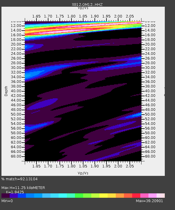
QM12 Camp Vic, Maine, USA - Earthquake Result Viewer
| Earthquake location: |
Near East Coast Of Honshu, Japan |
| Earthquake latitude/longitude: |
36.6/141.8 |
| Earthquake time(UTC): |
2014/06/15 (166) 18:19:15 GMT |
| Earthquake Depth: |
23 km |
| Earthquake Magnitude: |
5.7 MB |
| Earthquake Catalog/Contributor: |
NEIC PDE/NEIC COMCAT |
|
| Network: |
X8 Deep Structure of Three Continental Sutures in Eastern North America |
| Station: |
QM12 Camp Vic, Maine, USA |
| Lat/Lon: |
44.97 N/67.86 W |
| Elevation: |
15 m |
|
| Distance: |
94.5 deg |
| Az: |
20.619 deg |
| Baz: |
336.484 deg |
| Ray Param: |
0.04103374 |
| Estimated Moho Depth: |
11.25 km |
| Estimated Crust Vp/Vs: |
1.94 |
| Assumed Crust Vp: |
6.419 km/s |
| Estimated Crust Vs: |
3.305 km/s |
| Estimated Crust Poisson's Ratio: |
0.32 |
|
| Radial Match: |
92.13104 % |
| Radial Bump: |
334 |
| Transverse Match: |
93.71403 % |
| Transverse Bump: |
385 |
| SOD ConfigId: |
3390531 |
| Insert Time: |
2019-04-12 06:55:05.189 +0000 |
| GWidth: |
2.5 |
| Max Bumps: |
400 |
| Tol: |
0.001 |
|

Signal To Noise
| Channel | StoN | STA | LTA |
| X8:QM12: :HHZ:20140615T18:32:02.269993Z | 2.6301887 | 2.3055727E-6 | 8.7658077E-7 |
| X8:QM12: :HHN:20140615T18:32:02.269993Z | 2.1805346 | 5.690471E-5 | 2.6096679E-5 |
| X8:QM12: :HHE:20140615T18:32:02.269993Z | 2.4563403 | 3.7153158E-4 | 1.5125412E-4 |
| Arrivals |
| Ps | 1.7 SECOND |
| PpPs | 5.1 SECOND |
| PsPs/PpSs | 6.7 SECOND |


