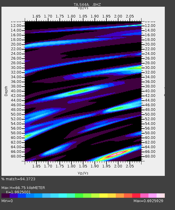
S44A Carbondale, IL, USA - Earthquake Result Viewer

Earthquake location: Andreanof Islands, Aleutian Is.
Earthquake latitude/longitude: 51.6/-178.3
Earthquake time(UTC): 2012/09/26 (270) 23:39:55 GMT
Earthquake Depth: 16 km
Earthquake Magnitude: 6.3 MB, 6.5 MS, 6.4 MW, 6.4 MW
Earthquake Catalog/Contributor: WHDF/NEIC
Network: TA USArray Transportable Network (new EarthScope stations)
Station: S44A Carbondale, IL, USA
Lat/Lon: 37.69 N/89.26 W
Elevation: 155 m
Distance: 61.0 deg
Az: 65.025 deg
Baz: 314.532 deg
Ray Param: 0.061119262
Estimated Moho Depth: 66.75 km
Estimated Crust Vp/Vs: 1.99
Assumed Crust Vp: 6.444 km/s
Estimated Crust Vs: 3.234 km/s
Estimated Crust Poisson's Ratio: 0.33
Radial Match: 94.3723 %
Radial Bump: 320
Transverse Match: 80.36908 %
Transverse Bump: 400
SOD ConfigId: 478790
Insert Time: 2013-02-22 23:28:38.347 +0000
GWidth: 2.5
Max Bumps: 400
Tol: 0.001

Signal To Noise

ChannelStoNSTALTA
TA:S44A: :BHZ:20120926T23:49:36.825027Z20.5054591.491047E-67.2714634E-8
TA:S44A: :BHN:20120926T23:49:36.825027Z5.59978966.654293E-71.1883113E-7
TA:S44A: :BHE:20120926T23:49:36.825027Z5.2629665.7033805E-71.0836818E-7
Arrivals
Ps11 SECOND
PpPs30 SECOND
PsPs/PpSs40 SECOND