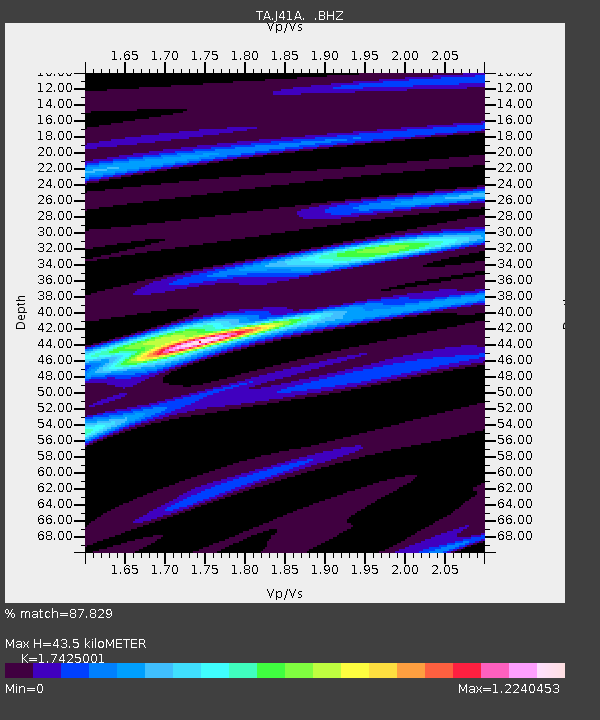
J41A Loganville, WI, USA - Earthquake Result Viewer
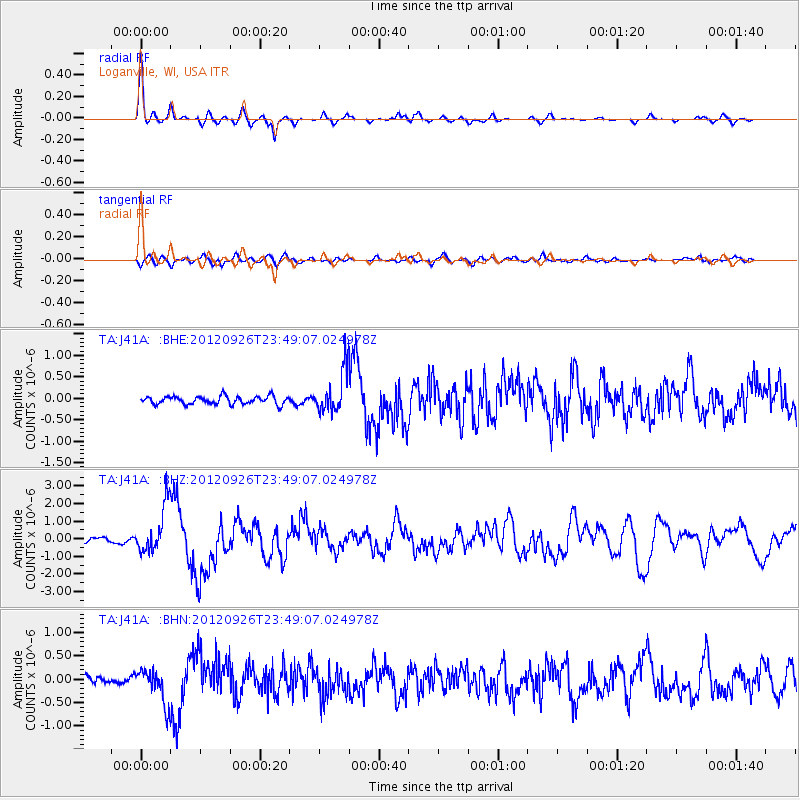
Earthquake location: Andreanof Islands, Aleutian Is.
Earthquake latitude/longitude: 51.6/-178.3
Earthquake time(UTC): 2012/09/26 (270) 23:39:55 GMT
Earthquake Depth: 16 km
Earthquake Magnitude: 6.3 MB, 6.5 MS, 6.4 MW, 6.4 MW
Earthquake Catalog/Contributor: WHDF/NEIC
Network: TA USArray Transportable Network (new EarthScope stations)
Station: J41A Loganville, WI, USA
Lat/Lon: 43.37 N/90.01 W
Elevation: 360 m
Distance: 56.7 deg
Az: 60.661 deg
Baz: 311.784 deg
Ray Param: 0.063928366
Estimated Moho Depth: 43.5 km
Estimated Crust Vp/Vs: 1.74
Assumed Crust Vp: 6.53 km/s
Estimated Crust Vs: 3.748 km/s
Estimated Crust Poisson's Ratio: 0.25
Radial Match: 87.829 %
Radial Bump: 275
Transverse Match: 74.40225 %
Transverse Bump: 400
SOD ConfigId: 478790
Insert Time: 2013-02-22 23:29:47.509 +0000
GWidth: 2.5
Max Bumps: 400
Tol: 0.001

Signal To Noise

ChannelStoNSTALTA
TA:J41A: :BHZ:20120926T23:49:07.024978Z8.3214441.3258991E-61.5933523E-7
TA:J41A: :BHN:20120926T23:49:07.024978Z2.82600623.7569654E-71.3294257E-7
TA:J41A: :BHE:20120926T23:49:07.024978Z5.2044934.907592E-79.429529E-8
Arrivals
Ps5.2 SECOND
PpPs17 SECOND
PsPs/PpSs23 SECOND