You are here: Home > Network List > TA - USArray Transportable Network (new EarthScope stations) Stations List
> Station S41A Jillco Farms, Salem, MO, USA > Earthquake Result Viewer
S41A Jillco Farms, Salem, MO, USA - Earthquake Result Viewer
| Earthquake location: |
Andreanof Islands, Aleutian Is. |
| Earthquake latitude/longitude: |
51.6/-178.3 |
| Earthquake time(UTC): |
2012/09/26 (270) 23:39:55 GMT |
| Earthquake Depth: |
16 km |
| Earthquake Magnitude: |
6.3 MB, 6.5 MS, 6.4 MW, 6.4 MW |
| Earthquake Catalog/Contributor: |
WHDF/NEIC |
|
| Network: |
TA USArray Transportable Network (new EarthScope stations) |
| Station: |
S41A Jillco Farms, Salem, MO, USA |
| Lat/Lon: |
37.59 N/91.75 W |
| Elevation: |
376 m |
|
| Distance: |
59.7 deg |
| Az: |
66.698 deg |
| Baz: |
313.845 deg |
| Ray Param: |
0.062003415 |
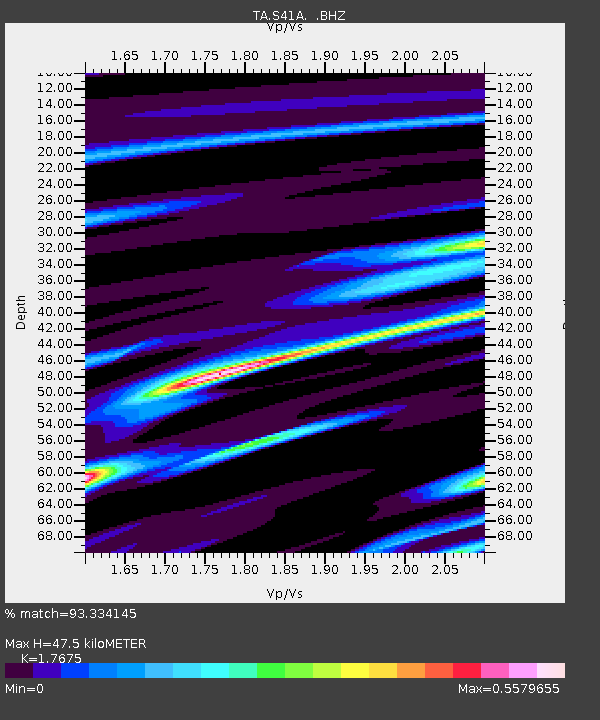
| Estimated Moho Depth: |
47.5 km |
| Estimated Crust Vp/Vs: |
1.77 |
| Assumed Crust Vp: |
6.53 km/s |
| Estimated Crust Vs: |
3.695 km/s |
| Estimated Crust Poisson's Ratio: |
0.26 |
|
| Radial Match: |
93.334145 % |
| Radial Bump: |
400 |
| Transverse Match: |
77.97364 % |
| Transverse Bump: |
400 |
| SOD ConfigId: |
478790 |
| Insert Time: |
2013-02-22 23:30:10.935 +0000 |
| GWidth: |
2.5 |
| Max Bumps: |
400 |
| Tol: |
0.001 |
|
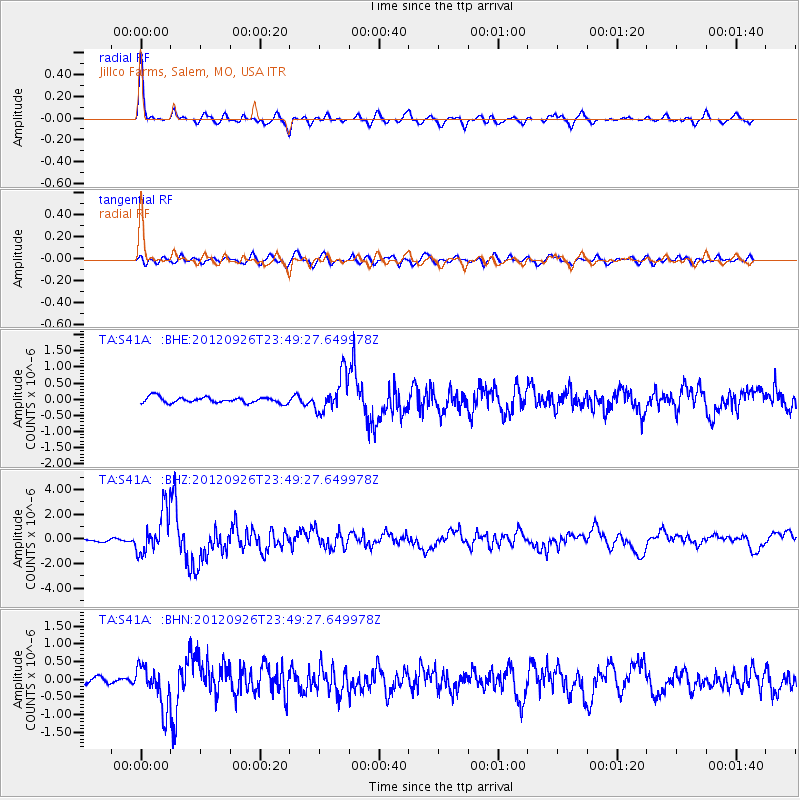
Signal To Noise
| Channel | StoN | STA | LTA |
| TA:S41A: :BHZ:20120926T23:49:27.649978Z | 14.221246 | 1.7197577E-6 | 1.2092877E-7 |
| TA:S41A: :BHN:20120926T23:49:27.649978Z | 5.2198834 | 5.801998E-7 | 1.1115187E-7 |
| TA:S41A: :BHE:20120926T23:49:27.649978Z | 6.149927 | 5.571182E-7 | 9.05894E-8 |
| Arrivals |
| Ps | 5.9 SECOND |
| PpPs | 19 SECOND |
| PsPs/PpSs | 25 SECOND |


