You are here: Home > Network List > G - GEOSCOPE Stations List
> Station WUS Wushi, Xinjiang Uygur, China > Earthquake Result Viewer
WUS Wushi, Xinjiang Uygur, China - Earthquake Result Viewer

| Earthquake location: |
Off East Coast Of Honshu, Japan |
| Earthquake latitude/longitude: |
39.5/143.0 |
| Earthquake time(UTC): |
1992/07/18 (200) 13:56:53 GMT |
| Earthquake Depth: |
21 km |
| Earthquake Magnitude: |
5.7 MB, 6.0 MS |
| Earthquake Catalog/Contributor: |
WHDF/NEIC |
|
| Network: |
G GEOSCOPE |
| Station: |
WUS Wushi, Xinjiang Uygur, China |
| Lat/Lon: |
41.20 N/79.22 E |
| Elevation: |
1457 m |
|
| Distance: |
47.7 deg |
| Az: |
293.688 deg |
| Baz: |
69.948 deg |
| Ray Param: |
0.06980553 |
| Estimated Moho Depth: |
67.75 km |
| Estimated Crust Vp/Vs: |
1.71 |
| Assumed Crust Vp: |
6.353 km/s |
| Estimated Crust Vs: |
3.726 km/s |
| Estimated Crust Poisson's Ratio: |
0.24 |
|
| Radial Match: |
95.73249 % |
| Radial Bump: |
372 |
| Transverse Match: |
91.31846 % |
| Transverse Bump: |
400 |
| SOD ConfigId: |
16938 |
| Insert Time: |
2010-02-27 00:49:27.575 +0000 |
| GWidth: |
2.5 |
| Max Bumps: |
400 |
| Tol: |
0.001 |
|
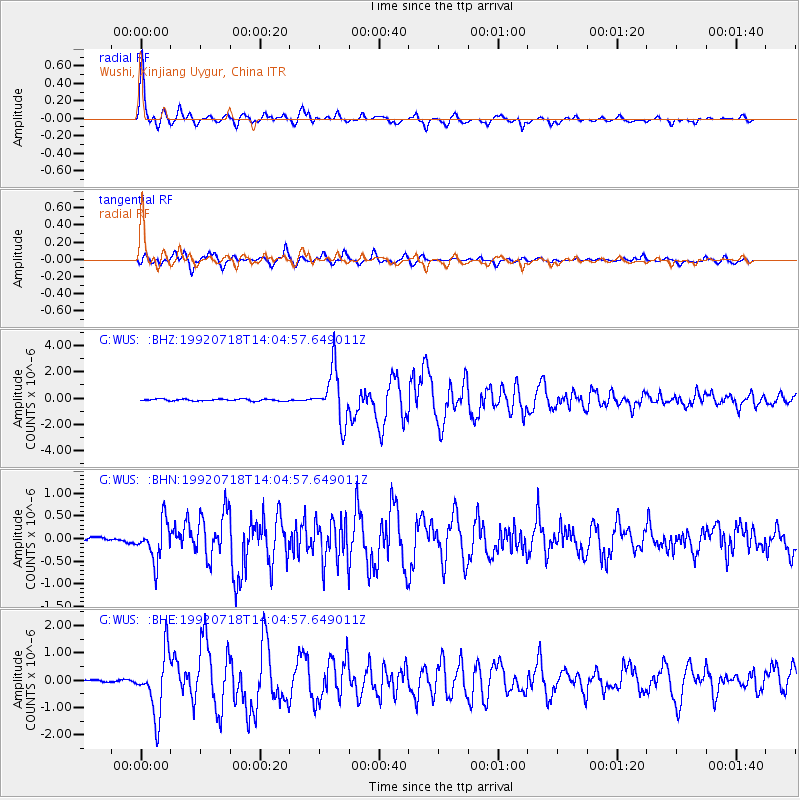
Signal To Noise
| Channel | StoN | STA | LTA |
| G:WUS: :BHN:19920718T14:04:57.649011Z | 8.356697 | 4.3225577E-7 | 5.1725674E-8 |
| G:WUS: :BHE:19920718T14:04:57.649011Z | 30.366858 | 1.1044064E-6 | 3.6368807E-8 |
| G:WUS: :BHZ:19920718T14:04:57.649011Z | 27.64802 | 1.9859476E-6 | 7.182965E-8 |
| Arrivals |
| Ps | 8.0 SECOND |
| PpPs | 27 SECOND |
| PsPs/PpSs | 35 SECOND |


