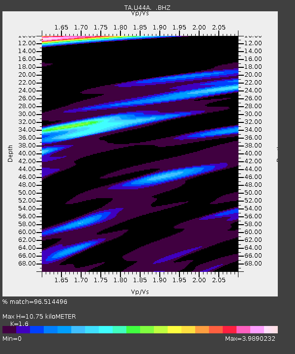
U44A Portageville, MO, USA - Earthquake Result Viewer
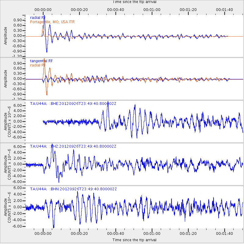
Earthquake location: Andreanof Islands, Aleutian Is.
Earthquake latitude/longitude: 51.6/-178.3
Earthquake time(UTC): 2012/09/26 (270) 23:39:55 GMT
Earthquake Depth: 16 km
Earthquake Magnitude: 6.3 MB, 6.5 MS, 6.4 MW, 6.4 MW
Earthquake Catalog/Contributor: WHDF/NEIC
Network: TA USArray Transportable Network (new EarthScope stations)
Station: U44A Portageville, MO, USA
Lat/Lon: 36.50 N/89.69 W
Elevation: 89 m
Distance: 61.6 deg
Az: 66.263 deg
Baz: 314.867 deg
Ray Param: 0.06073725
Estimated Moho Depth: 10.75 km
Estimated Crust Vp/Vs: 1.60
Assumed Crust Vp: 6.444 km/s
Estimated Crust Vs: 4.027 km/s
Estimated Crust Poisson's Ratio: 0.18
Radial Match: 96.514496 %
Radial Bump: 400
Transverse Match: 81.90966 %
Transverse Bump: 400
SOD ConfigId: 478790
Insert Time: 2013-02-22 23:31:08.079 +0000
GWidth: 2.5
Max Bumps: 400
Tol: 0.001

Signal To Noise

ChannelStoNSTALTA
TA:U44A: :BHZ:20120926T23:49:40.800002Z5.4694822.0385235E-63.727087E-7
TA:U44A: :BHN:20120926T23:49:40.800002Z2.73635861.5443956E-65.643981E-7
TA:U44A: :BHE:20120926T23:49:40.800002Z4.16688161.924648E-64.6189172E-7
Arrivals
Ps1.1 SECOND
PpPs4.1 SECOND
PsPs/PpSs5.2 SECOND