R41A Rosebud, MO, USA - Earthquake Result Viewer
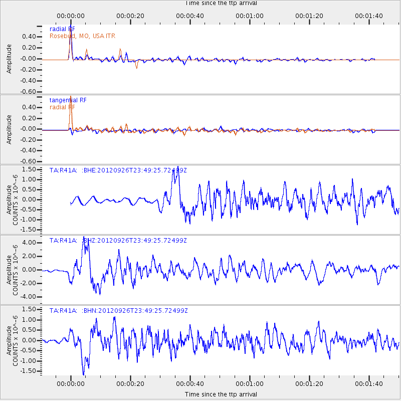
Earthquake location: Andreanof Islands, Aleutian Is.
Earthquake latitude/longitude: 51.6/-178.3
Earthquake time(UTC): 2012/09/26 (270) 23:39:55 GMT
Earthquake Depth: 16 km
Earthquake Magnitude: 6.3 MB, 6.5 MS, 6.4 MW, 6.4 MW
Earthquake Catalog/Contributor: WHDF/NEIC
Network: TA USArray Transportable Network (new EarthScope stations)
Station: R41A Rosebud, MO, USA
Lat/Lon: 38.30 N/91.38 W
Elevation: 257 m
Distance: 59.4 deg
Az: 65.872 deg
Baz: 313.65 deg
Ray Param: 0.062188234
Estimated Moho Depth: 43.0 km
Estimated Crust Vp/Vs: 1.96
Assumed Crust Vp: 6.498 km/s
Estimated Crust Vs: 3.319 km/s
Estimated Crust Poisson's Ratio: 0.32
Radial Match: 95.74108 %
Radial Bump: 342
Transverse Match: 77.266266 %
Transverse Bump: 400
SOD ConfigId: 478790
Insert Time: 2013-02-22 23:31:20.050 +0000
GWidth: 2.5
Max Bumps: 400
Tol: 0.001

Signal To Noise

ChannelStoNSTALTA
TA:R41A: :BHZ:20120926T23:49:25.72499Z16.0658282.0273646E-61.2619111E-7
TA:R41A: :BHN:20120926T23:49:25.72499Z7.74925146.69211E-78.635815E-8
TA:R41A: :BHE:20120926T23:49:25.72499Z5.32284366.194579E-71.1637726E-7
Arrivals
Ps6.6 SECOND
PpPs19 SECOND
PsPs/PpSs25 SECOND