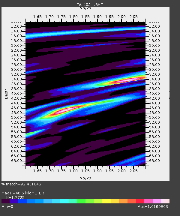
I40A Norwalk, WI, USA - Earthquake Result Viewer

Earthquake location: Andreanof Islands, Aleutian Is.
Earthquake latitude/longitude: 51.6/-178.3
Earthquake time(UTC): 2012/09/26 (270) 23:39:55 GMT
Earthquake Depth: 16 km
Earthquake Magnitude: 6.3 MB, 6.5 MS, 6.4 MW, 6.4 MW
Earthquake Catalog/Contributor: WHDF/NEIC
Network: TA USArray Transportable Network (new EarthScope stations)
Station: I40A Norwalk, WI, USA
Lat/Lon: 43.89 N/90.62 W
Elevation: 419 m
Distance: 56.1 deg
Az: 60.538 deg
Baz: 311.3 deg
Ray Param: 0.06437034
Estimated Moho Depth: 46.5 km
Estimated Crust Vp/Vs: 1.77
Assumed Crust Vp: 6.53 km/s
Estimated Crust Vs: 3.684 km/s
Estimated Crust Poisson's Ratio: 0.27
Radial Match: 92.431046 %
Radial Bump: 342
Transverse Match: 77.06699 %
Transverse Bump: 400
SOD ConfigId: 478790
Insert Time: 2013-02-22 23:31:56.996 +0000
GWidth: 2.5
Max Bumps: 400
Tol: 0.001

Signal To Noise

ChannelStoNSTALTA
TA:I40A: :BHZ:20120926T23:49:02.200027Z11.079371.2860968E-61.1608032E-7
TA:I40A: :BHN:20120926T23:49:02.200027Z2.37312462.857044E-71.2039165E-7
TA:I40A: :BHE:20120926T23:49:02.200027Z5.59630735.296613E-79.464479E-8
Arrivals
Ps5.8 SECOND
PpPs19 SECOND
PsPs/PpSs25 SECOND