You are here: Home > Network List > G - GEOSCOPE Stations List
> Station WUS Wushi, Xinjiang Uygur, China > Earthquake Result Viewer
WUS Wushi, Xinjiang Uygur, China - Earthquake Result Viewer
| Earthquake location: |
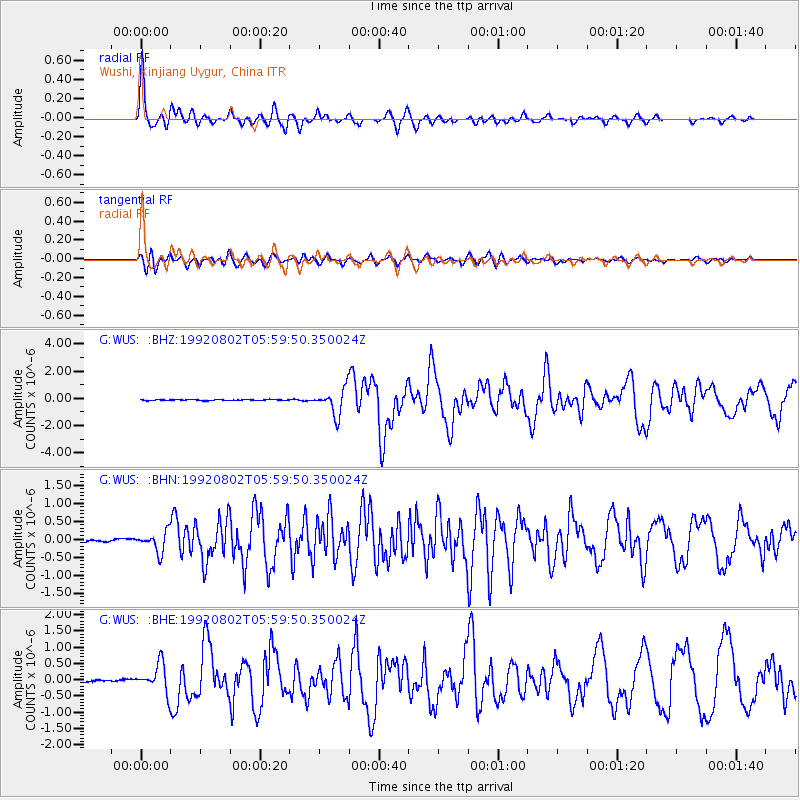
Halmahera, Indonesia |
| Earthquake latitude/longitude: |
-0.9/127.6 |
| Earthquake time(UTC): |
1992/08/02 (215) 05:50:13 GMT |
| Earthquake Depth: |
33 km |
| Earthquake Magnitude: |
5.8 MB, 6.2 MS, 6.6 UNKNOWN |
| Earthquake Catalog/Contributor: |
WHDF/NEIC |
|
| Network: |
G GEOSCOPE |
| Station: |
WUS Wushi, Xinjiang Uygur, China |
| Lat/Lon: |
41.20 N/79.22 E |
| Elevation: |
1457 m |
|
| Distance: |
60.6 deg |
| Az: |
319.648 deg |
| Baz: |
120.916 deg |
| Ray Param: |
0.061373174 |
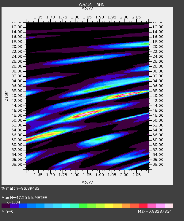
| Estimated Moho Depth: |
47.25 km |
| Estimated Crust Vp/Vs: |
1.84 |
| Assumed Crust Vp: |
6.353 km/s |
| Estimated Crust Vs: |
3.453 km/s |
| Estimated Crust Poisson's Ratio: |
0.29 |
|
| Radial Match: |
96.39482 % |
| Radial Bump: |
376 |
| Transverse Match: |
84.32055 % |
| Transverse Bump: |
400 |
| SOD ConfigId: |
16938 |
| Insert Time: |
2010-02-27 00:49:33.541 +0000 |
| GWidth: |
2.5 |
| Max Bumps: |
400 |
| Tol: |
0.001 |
|
Signal To Noise
| Channel | StoN | STA | LTA |
| G:WUS: :BHN:19920802T05:59:50.350024Z | 5.371147 | 2.8077116E-7 | 5.227397E-8 |
| G:WUS: :BHE:19920802T05:59:50.350024Z | 12.890423 | 4.402021E-7 | 3.4149544E-8 |
| G:WUS: :BHZ:19920802T05:59:50.350024Z | 28.173391 | 9.659823E-7 | 3.428704E-8 |
| Arrivals |
| Ps | 6.5 SECOND |
| PpPs | 20 SECOND |
| PsPs/PpSs | 27 SECOND |


