You are here: Home > Network List > TA - USArray Transportable Network (new EarthScope stations) Stations List
> Station F37A Hinrichs Farm, Grantsburg, WI, USA > Earthquake Result Viewer
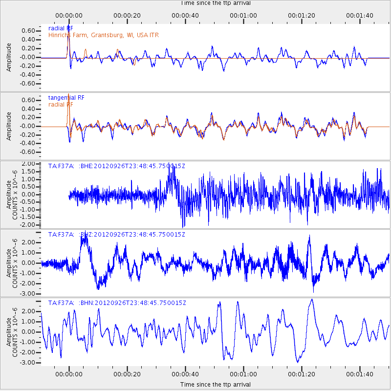
F37A Hinrichs Farm, Grantsburg, WI, USA - Earthquake Result Viewer
*The percent match for this event was below the threshold and hence no stack was calculated.
| Earthquake location: |
Andreanof Islands, Aleutian Is. |
| Earthquake latitude/longitude: |
51.6/-178.3 |
| Earthquake time(UTC): |
2012/09/26 (270) 23:39:55 GMT |
| Earthquake Depth: |
16 km |
| Earthquake Magnitude: |
6.3 MB, 6.5 MS, 6.4 MW, 6.4 MW |
| Earthquake Catalog/Contributor: |
WHDF/NEIC |
|
| Network: |
TA USArray Transportable Network (new EarthScope stations) |
| Station: |
F37A Hinrichs Farm, Grantsburg, WI, USA |
| Lat/Lon: |
45.72 N/92.63 W |
| Elevation: |
296 m |
|
| Distance: |
53.8 deg |
| Az: |
59.966 deg |
| Baz: |
309.561 deg |
| Ray Param: |
$rayparam |
*The percent match for this event was below the threshold and hence was not used in the summary stack. |
|
| Radial Match: |
65.9702 % |
| Radial Bump: |
400 |
| Transverse Match: |
59.52886 % |
| Transverse Bump: |
400 |
| SOD ConfigId: |
478790 |
| Insert Time: |
2013-02-22 23:34:05.345 +0000 |
| GWidth: |
2.5 |
| Max Bumps: |
400 |
| Tol: |
0.001 |
|
Signal To Noise
| Channel | StoN | STA | LTA |
| TA:F37A: :BHZ:20120926T23:48:45.750015Z | 4.3557777 | 9.867127E-7 | 2.2652962E-7 |
| TA:F37A: :BHN:20120926T23:48:45.750015Z | 1.0036085 | 1.1071929E-6 | 1.103212E-6 |
| TA:F37A: :BHE:20120926T23:48:45.750015Z | 2.1538022 | 5.9252056E-7 | 2.7510447E-7 |
| Arrivals |
| Ps | |
| PpPs | |
| PsPs/PpSs | |


