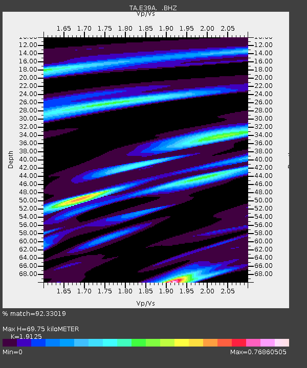
E39A Mellen, WI, USA - Earthquake Result Viewer
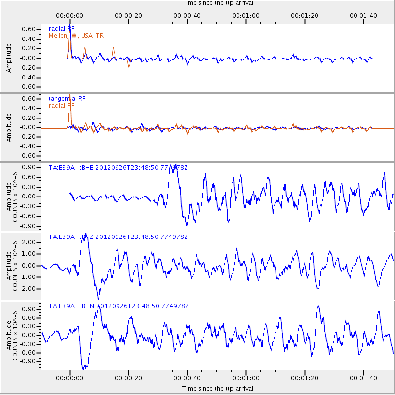
Earthquake location: Andreanof Islands, Aleutian Is.
Earthquake latitude/longitude: 51.6/-178.3
Earthquake time(UTC): 2012/09/26 (270) 23:39:55 GMT
Earthquake Depth: 16 km
Earthquake Magnitude: 6.3 MB, 6.5 MS, 6.4 MW, 6.4 MW
Earthquake Catalog/Contributor: WHDF/NEIC
Network: TA USArray Transportable Network (new EarthScope stations)
Station: E39A Mellen, WI, USA
Lat/Lon: 46.38 N/90.56 W
Elevation: 426 m
Distance: 54.5 deg
Az: 58.208 deg
Baz: 310.017 deg
Ray Param: 0.06540865
Estimated Moho Depth: 69.75 km
Estimated Crust Vp/Vs: 1.91
Assumed Crust Vp: 6.467 km/s
Estimated Crust Vs: 3.381 km/s
Estimated Crust Poisson's Ratio: 0.31
Radial Match: 92.33019 %
Radial Bump: 253
Transverse Match: 61.563236 %
Transverse Bump: 400
SOD ConfigId: 478790
Insert Time: 2013-02-22 23:34:30.965 +0000
GWidth: 2.5
Max Bumps: 400
Tol: 0.001

Signal To Noise

ChannelStoNSTALTA
TA:E39A: :BHZ:20120926T23:48:50.774978Z7.302471.0421646E-61.4271399E-7
TA:E39A: :BHN:20120926T23:48:50.774978Z2.99368384.7101253E-71.5733542E-7
TA:E39A: :BHE:20120926T23:48:50.774978Z7.670114.11168E-75.360653E-8
Arrivals
Ps10 SECOND
PpPs30 SECOND
PsPs/PpSs40 SECOND