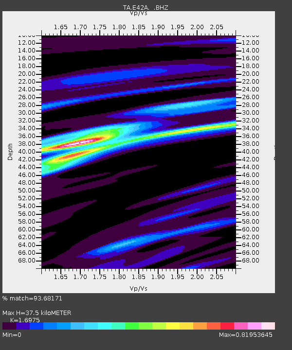
E42A Champion, MI, USA - Earthquake Result Viewer

Earthquake location: Andreanof Islands, Aleutian Is.
Earthquake latitude/longitude: 51.6/-178.3
Earthquake time(UTC): 2012/09/26 (270) 23:39:55 GMT
Earthquake Depth: 16 km
Earthquake Magnitude: 6.3 MB, 6.5 MS, 6.4 MW, 6.4 MW
Earthquake Catalog/Contributor: WHDF/NEIC
Network: TA USArray Transportable Network (new EarthScope stations)
Station: E42A Champion, MI, USA
Lat/Lon: 46.43 N/87.91 W
Elevation: 475 m
Distance: 55.8 deg
Az: 56.712 deg
Baz: 311.069 deg
Ray Param: 0.064521156
Estimated Moho Depth: 37.5 km
Estimated Crust Vp/Vs: 1.70
Assumed Crust Vp: 6.472 km/s
Estimated Crust Vs: 3.813 km/s
Estimated Crust Poisson's Ratio: 0.23
Radial Match: 93.68171 %
Radial Bump: 254
Transverse Match: 75.47138 %
Transverse Bump: 400
SOD ConfigId: 478790
Insert Time: 2013-02-22 23:34:54.727 +0000
GWidth: 2.5
Max Bumps: 400
Tol: 0.001

Signal To Noise

ChannelStoNSTALTA
TA:E42A: :BHZ:20120926T23:49:00.550002Z8.664111.1342852E-61.3091768E-7
TA:E42A: :BHN:20120926T23:49:00.550002Z3.3133354.2743864E-71.2900556E-7
TA:E42A: :BHE:20120926T23:49:00.550002Z3.6415634.310323E-71.1836464E-7
Arrivals
Ps4.3 SECOND
PpPs15 SECOND
PsPs/PpSs19 SECOND