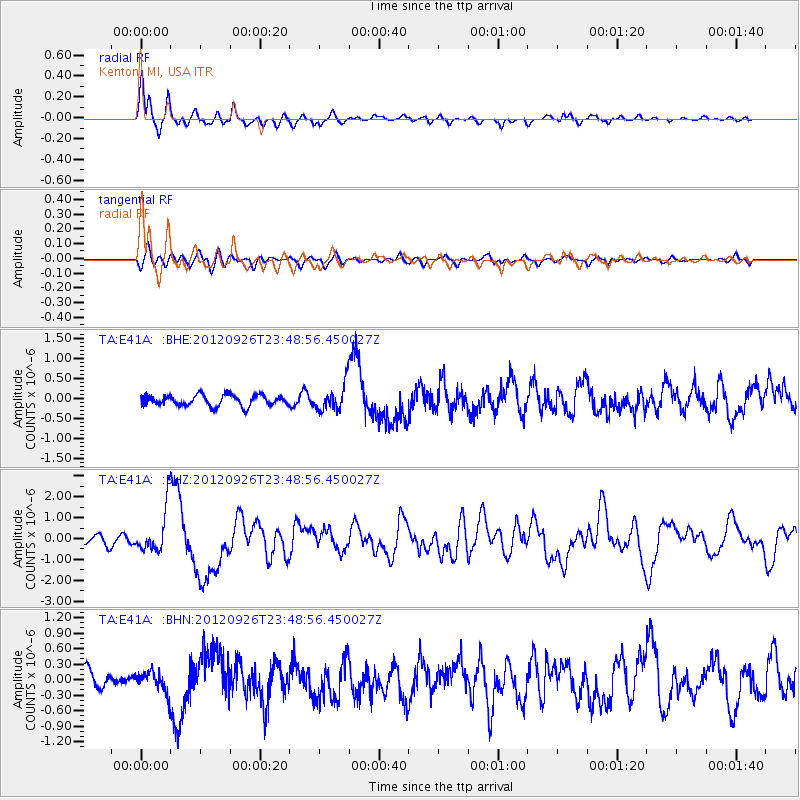
E41A Kenton, MI, USA - Earthquake Result Viewer
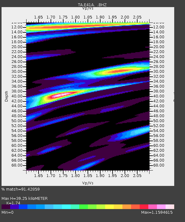
Earthquake location: Andreanof Islands, Aleutian Is.
Earthquake latitude/longitude: 51.6/-178.3
Earthquake time(UTC): 2012/09/26 (270) 23:39:55 GMT
Earthquake Depth: 16 km
Earthquake Magnitude: 6.3 MB, 6.5 MS, 6.4 MW, 6.4 MW
Earthquake Catalog/Contributor: WHDF/NEIC
Network: TA USArray Transportable Network (new EarthScope stations)
Station: E41A Kenton, MI, USA
Lat/Lon: 46.46 N/88.96 W
Elevation: 377 m
Distance: 55.3 deg
Az: 57.256 deg
Baz: 310.618 deg
Ray Param: 0.06489389
Estimated Moho Depth: 39.25 km
Estimated Crust Vp/Vs: 1.74
Assumed Crust Vp: 6.467 km/s
Estimated Crust Vs: 3.716 km/s
Estimated Crust Poisson's Ratio: 0.25
Radial Match: 91.42859 %
Radial Bump: 400
Transverse Match: 64.7605 %
Transverse Bump: 400
SOD ConfigId: 478790
Insert Time: 2013-02-22 23:35:05.242 +0000
GWidth: 2.5
Max Bumps: 400
Tol: 0.001

Signal To Noise

ChannelStoNSTALTA
TA:E41A: :BHZ:20120926T23:48:56.450027Z7.2063191.0793292E-61.4977539E-7
TA:E41A: :BHN:20120926T23:48:56.450027Z1.33533991.9990489E-71.4970337E-7
TA:E41A: :BHE:20120926T23:48:56.450027Z2.41300233.2303575E-71.3387296E-7
Arrivals
Ps4.7 SECOND
PpPs16 SECOND
PsPs/PpSs20 SECOND