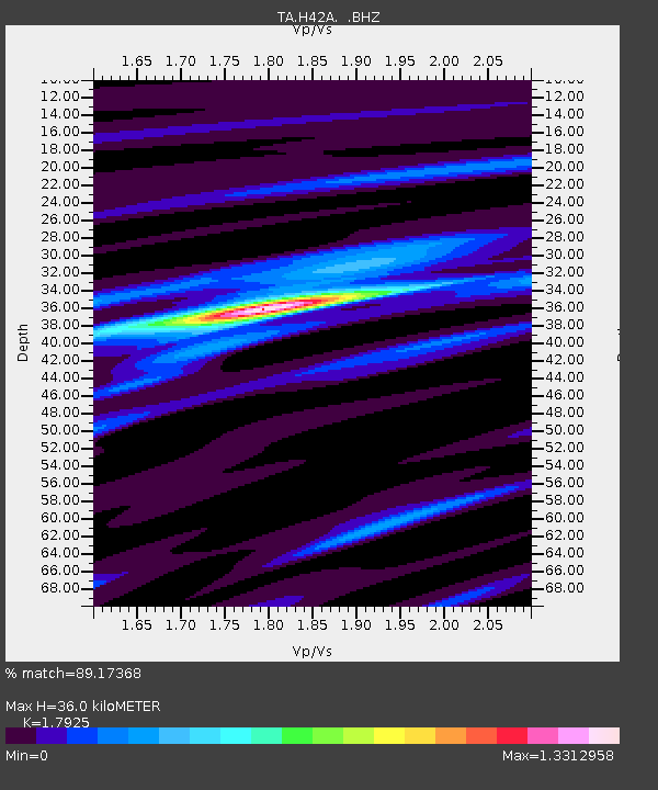
H42A Shiocton, WI, USA - Earthquake Result Viewer

Earthquake location: Andreanof Islands, Aleutian Is.
Earthquake latitude/longitude: 51.6/-178.3
Earthquake time(UTC): 2012/09/26 (270) 23:39:55 GMT
Earthquake Depth: 16 km
Earthquake Magnitude: 6.3 MB, 6.5 MS, 6.4 MW, 6.4 MW
Earthquake Catalog/Contributor: WHDF/NEIC
Network: TA USArray Transportable Network (new EarthScope stations)
Station: H42A Shiocton, WI, USA
Lat/Lon: 44.51 N/88.53 W
Elevation: 244 m
Distance: 56.8 deg
Az: 58.788 deg
Baz: 311.782 deg
Ray Param: 0.06390409
Estimated Moho Depth: 36.0 km
Estimated Crust Vp/Vs: 1.79
Assumed Crust Vp: 6.41 km/s
Estimated Crust Vs: 3.576 km/s
Estimated Crust Poisson's Ratio: 0.27
Radial Match: 89.17368 %
Radial Bump: 400
Transverse Match: 72.39087 %
Transverse Bump: 400
SOD ConfigId: 478790
Insert Time: 2013-02-22 23:35:48.705 +0000
GWidth: 2.5
Max Bumps: 400
Tol: 0.001

Signal To Noise

ChannelStoNSTALTA
TA:H42A: :BHZ:20120926T23:49:07.274978Z8.4261621.2549474E-61.4893465E-7
TA:H42A: :BHN:20120926T23:49:07.274978Z2.8917984.4741338E-71.5471807E-7
TA:H42A: :BHE:20120926T23:49:07.274978Z4.02776055.363266E-71.3315751E-7
Arrivals
Ps4.7 SECOND
PpPs15 SECOND
PsPs/PpSs20 SECOND