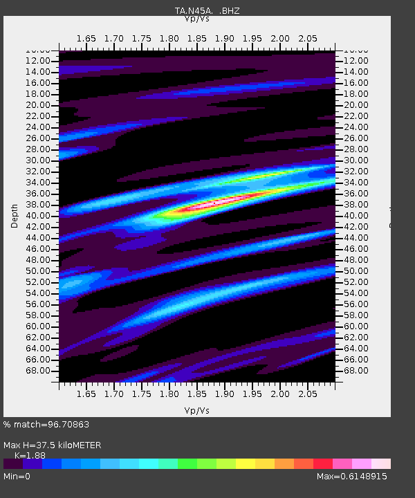
N45A Kentland, IN, USA - Earthquake Result Viewer
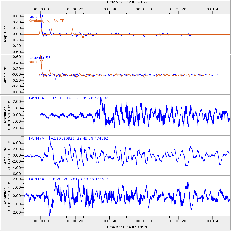
Earthquake location: Andreanof Islands, Aleutian Is.
Earthquake latitude/longitude: 51.6/-178.3
Earthquake time(UTC): 2012/09/26 (270) 23:39:55 GMT
Earthquake Depth: 16 km
Earthquake Magnitude: 6.3 MB, 6.5 MS, 6.4 MW, 6.4 MW
Earthquake Catalog/Contributor: WHDF/NEIC
Network: TA USArray Transportable Network (new EarthScope stations)
Station: N45A Kentland, IN, USA
Lat/Lon: 40.85 N/87.51 W
Elevation: 206 m
Distance: 59.8 deg
Az: 61.343 deg
Baz: 313.815 deg
Ray Param: 0.06192548
Estimated Moho Depth: 37.5 km
Estimated Crust Vp/Vs: 1.88
Assumed Crust Vp: 6.498 km/s
Estimated Crust Vs: 3.456 km/s
Estimated Crust Poisson's Ratio: 0.30
Radial Match: 96.70863 %
Radial Bump: 212
Transverse Match: 82.07809 %
Transverse Bump: 400
SOD ConfigId: 478790
Insert Time: 2013-02-22 23:36:17.870 +0000
GWidth: 2.5
Max Bumps: 400
Tol: 0.001

Signal To Noise

ChannelStoNSTALTA
TA:N45A: :BHZ:20120926T23:49:28.47499Z8.122971.3241632E-61.6301466E-7
TA:N45A: :BHN:20120926T23:49:28.47499Z2.6462644.4920176E-71.6974941E-7
TA:N45A: :BHE:20120926T23:49:28.47499Z2.92534115.949437E-72.0337583E-7
Arrivals
Ps5.3 SECOND
PpPs16 SECOND
PsPs/PpSs21 SECOND