You are here: Home > Network List > YB13 - Continental Dynamics/Cent. Anatolian Tectonics:Surface to Mantle Dynamics During Stations List
> Station AT18 Akbudak,Gaziantep,Turkey > Earthquake Result Viewer
AT18 Akbudak,Gaziantep,Turkey - Earthquake Result Viewer
| Earthquake location: |
Near East Coast Of Honshu, Japan |
| Earthquake latitude/longitude: |
36.6/141.8 |
| Earthquake time(UTC): |
2014/06/15 (166) 18:19:15 GMT |
| Earthquake Depth: |
23 km |
| Earthquake Magnitude: |
5.7 MB |
| Earthquake Catalog/Contributor: |
NEIC PDE/NEIC COMCAT |
|
| Network: |
YB Continental Dynamics/Cent. Anatolian Tectonics:Surface to Mantle Dynamics During |
| Station: |
AT18 Akbudak,Gaziantep,Turkey |
| Lat/Lon: |
37.44 N/37.96 E |
| Elevation: |
546 m |
|
| Distance: |
78.1 deg |
| Az: |
307.818 deg |
| Baz: |
52.963 deg |
| Ray Param: |
0.049871743 |
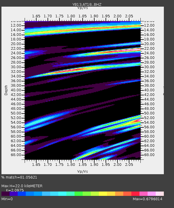
| Estimated Moho Depth: |
22.0 km |
| Estimated Crust Vp/Vs: |
2.10 |
| Assumed Crust Vp: |
6.247 km/s |
| Estimated Crust Vs: |
2.978 km/s |
| Estimated Crust Poisson's Ratio: |
0.35 |
|
| Radial Match: |
81.05621 % |
| Radial Bump: |
400 |
| Transverse Match: |
69.886566 % |
| Transverse Bump: |
400 |
| SOD ConfigId: |
3390531 |
| Insert Time: |
2019-04-12 06:56:06.836 +0000 |
| GWidth: |
2.5 |
| Max Bumps: |
400 |
| Tol: |
0.001 |
|

Signal To Noise
| Channel | StoN | STA | LTA |
| YB:AT18: :BHZ:20140615T18:30:41.120029Z | 9.521146 | 6.276803E-7 | 6.592487E-8 |
| YB:AT18: :BHN:20140615T18:30:41.120029Z | 1.8038269 | 1.1947363E-7 | 6.6233426E-8 |
| YB:AT18: :BHE:20140615T18:30:41.120029Z | 1.3575486 | 1.0626449E-7 | 7.827674E-8 |
| Arrivals |
| Ps | 4.0 SECOND |
| PpPs | 11 SECOND |
| PsPs/PpSs | 15 SECOND |


