You are here: Home > Network List > TA - USArray Transportable Network (new EarthScope stations) Stations List
> Station M46A Old House Field, Plymouth, IN, USA > Earthquake Result Viewer
M46A Old House Field, Plymouth, IN, USA - Earthquake Result Viewer

| Earthquake location: |
Andreanof Islands, Aleutian Is. |
| Earthquake latitude/longitude: |
51.6/-178.3 |
| Earthquake time(UTC): |
2012/09/26 (270) 23:39:55 GMT |
| Earthquake Depth: |
16 km |
| Earthquake Magnitude: |
6.3 MB, 6.5 MS, 6.4 MW, 6.4 MW |
| Earthquake Catalog/Contributor: |
WHDF/NEIC |
|
| Network: |
TA USArray Transportable Network (new EarthScope stations) |
| Station: |
M46A Old House Field, Plymouth, IN, USA |
| Lat/Lon: |
41.41 N/86.35 W |
| Elevation: |
242 m |
|
| Distance: |
60.1 deg |
| Az: |
60.176 deg |
| Baz: |
313.989 deg |
| Ray Param: |
0.061766915 |
| Estimated Moho Depth: |
36.0 km |
| Estimated Crust Vp/Vs: |
2.10 |
| Assumed Crust Vp: |
6.498 km/s |
| Estimated Crust Vs: |
3.098 km/s |
| Estimated Crust Poisson's Ratio: |
0.35 |
|
| Radial Match: |
92.58428 % |
| Radial Bump: |
335 |
| Transverse Match: |
76.223625 % |
| Transverse Bump: |
400 |
| SOD ConfigId: |
478790 |
| Insert Time: |
2013-02-22 23:37:45.319 +0000 |
| GWidth: |
2.5 |
| Max Bumps: |
400 |
| Tol: |
0.001 |
|
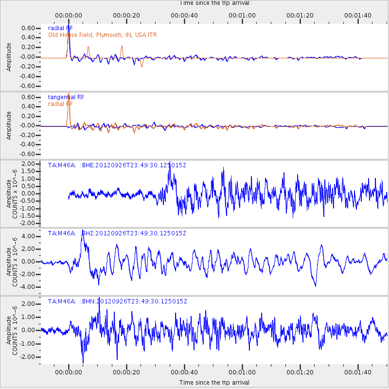
Signal To Noise
| Channel | StoN | STA | LTA |
| TA:M46A: :BHZ:20120926T23:49:30.125015Z | 8.939816 | 1.5169476E-6 | 1.6968441E-7 |
| TA:M46A: :BHN:20120926T23:49:30.125015Z | 3.2531865 | 5.114221E-7 | 1.5720653E-7 |
| TA:M46A: :BHE:20120926T23:49:30.125015Z | 3.5317242 | 5.0844756E-7 | 1.4396582E-7 |
| Arrivals |
| Ps | 6.3 SECOND |
| PpPs | 16 SECOND |
| PsPs/PpSs | 23 SECOND |


