You are here: Home > Network List > TA - USArray Transportable Network (new EarthScope stations) Stations List
> Station L42A Oliver, Polo, IL, USA > Earthquake Result Viewer
L42A Oliver, Polo, IL, USA - Earthquake Result Viewer
| Earthquake location: |
Andreanof Islands, Aleutian Is. |
| Earthquake latitude/longitude: |
51.6/-178.3 |
| Earthquake time(UTC): |
2012/09/26 (270) 23:39:55 GMT |
| Earthquake Depth: |
16 km |
| Earthquake Magnitude: |
6.3 MB, 6.5 MS, 6.4 MW, 6.4 MW |
| Earthquake Catalog/Contributor: |
WHDF/NEIC |
|
| Network: |
TA USArray Transportable Network (new EarthScope stations) |
| Station: |
L42A Oliver, Polo, IL, USA |
| Lat/Lon: |
42.00 N/89.67 W |
| Elevation: |
257 m |
|
| Distance: |
57.8 deg |
| Az: |
61.655 deg |
| Baz: |
312.555 deg |
| Ray Param: |
0.06321673 |
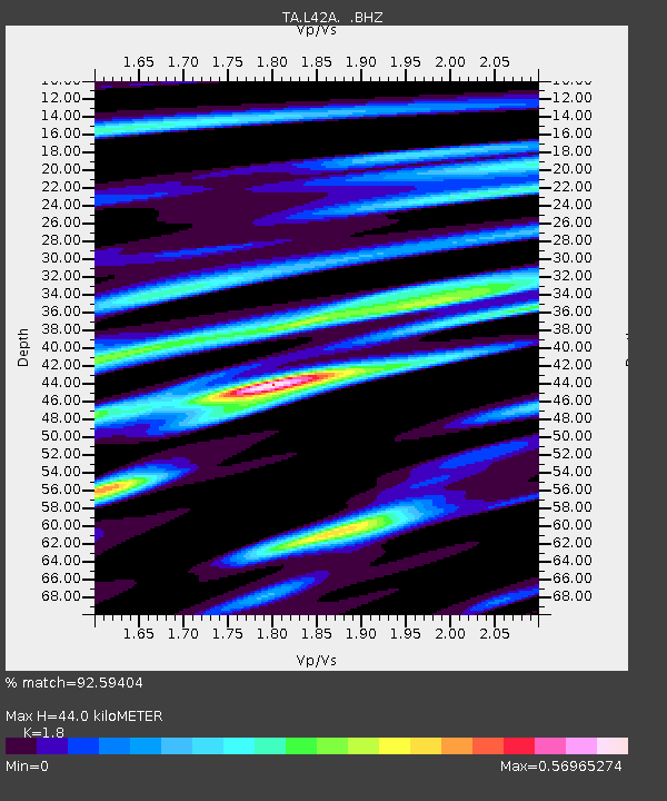
| Estimated Moho Depth: |
44.0 km |
| Estimated Crust Vp/Vs: |
1.80 |
| Assumed Crust Vp: |
6.571 km/s |
| Estimated Crust Vs: |
3.65 km/s |
| Estimated Crust Poisson's Ratio: |
0.28 |
|
| Radial Match: |
92.59404 % |
| Radial Bump: |
348 |
| Transverse Match: |
63.686646 % |
| Transverse Bump: |
400 |
| SOD ConfigId: |
478790 |
| Insert Time: |
2013-02-22 23:37:59.623 +0000 |
| GWidth: |
2.5 |
| Max Bumps: |
400 |
| Tol: |
0.001 |
|
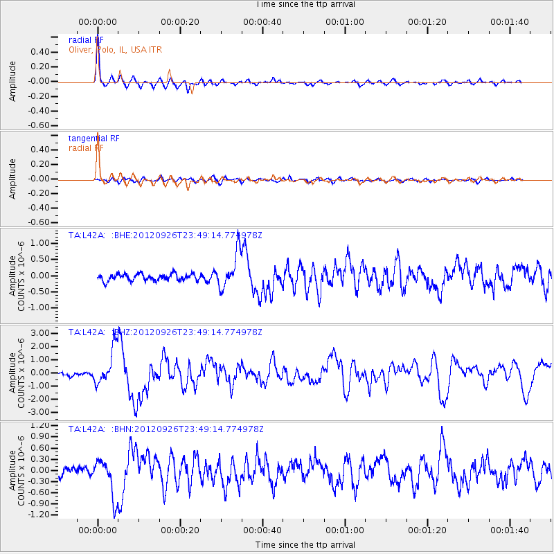
Signal To Noise
| Channel | StoN | STA | LTA |
| TA:L42A: :BHZ:20120926T23:49:14.774978Z | 9.49502 | 1.4420178E-6 | 1.5187096E-7 |
| TA:L42A: :BHN:20120926T23:49:14.774978Z | 5.1618805 | 5.315872E-7 | 1.0298324E-7 |
| TA:L42A: :BHE:20120926T23:49:14.774978Z | 5.516794 | 5.7811127E-7 | 1.0479116E-7 |
| Arrivals |
| Ps | 5.6 SECOND |
| PpPs | 18 SECOND |
| PsPs/PpSs | 23 SECOND |


