You are here: Home > Network List > TA - USArray Transportable Network (new EarthScope stations) Stations List
> Station Q47A Bedord North Lawrence Stars, Bedford, IN, USA > Earthquake Result Viewer
Q47A Bedord North Lawrence Stars, Bedford, IN, USA - Earthquake Result Viewer

| Earthquake location: |
Andreanof Islands, Aleutian Is. |
| Earthquake latitude/longitude: |
51.6/-178.3 |
| Earthquake time(UTC): |
2012/09/26 (270) 23:39:55 GMT |
| Earthquake Depth: |
16 km |
| Earthquake Magnitude: |
6.3 MB, 6.5 MS, 6.4 MW, 6.4 MW |
| Earthquake Catalog/Contributor: |
WHDF/NEIC |
|
| Network: |
TA USArray Transportable Network (new EarthScope stations) |
| Station: |
Q47A Bedord North Lawrence Stars, Bedford, IN, USA |
| Lat/Lon: |
38.94 N/86.43 W |
| Elevation: |
230 m |
|
| Distance: |
61.8 deg |
| Az: |
62.238 deg |
| Baz: |
314.945 deg |
| Ray Param: |
0.06066241 |
| Estimated Moho Depth: |
67.75 km |
| Estimated Crust Vp/Vs: |
1.99 |
| Assumed Crust Vp: |
6.444 km/s |
| Estimated Crust Vs: |
3.238 km/s |
| Estimated Crust Poisson's Ratio: |
0.33 |
|
| Radial Match: |
94.902405 % |
| Radial Bump: |
268 |
| Transverse Match: |
70.60513 % |
| Transverse Bump: |
400 |
| SOD ConfigId: |
478790 |
| Insert Time: |
2013-02-22 23:38:08.697 +0000 |
| GWidth: |
2.5 |
| Max Bumps: |
400 |
| Tol: |
0.001 |
|
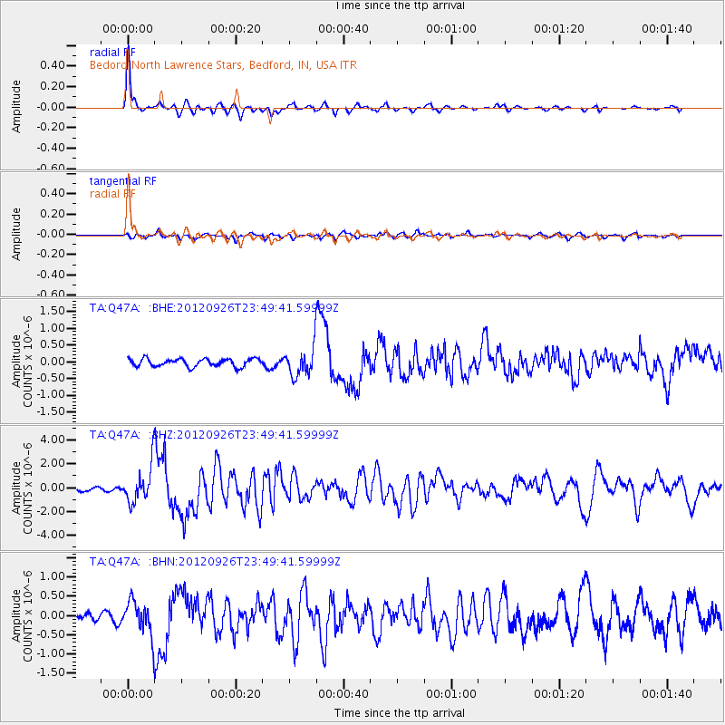
Signal To Noise
| Channel | StoN | STA | LTA |
| TA:Q47A: :BHZ:20120926T23:49:41.59999Z | 11.253091 | 1.5309931E-6 | 1.360509E-7 |
| TA:Q47A: :BHN:20120926T23:49:41.59999Z | 3.87869 | 4.2535282E-7 | 1.09664036E-7 |
| TA:Q47A: :BHE:20120926T23:49:41.59999Z | 3.6323814 | 4.2609926E-7 | 1.1730576E-7 |
| Arrivals |
| Ps | 11 SECOND |
| PpPs | 30 SECOND |
| PsPs/PpSs | 41 SECOND |


