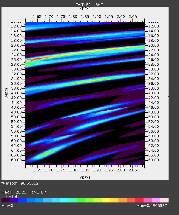
T48A Bowling Green, KY, USA - Earthquake Result Viewer
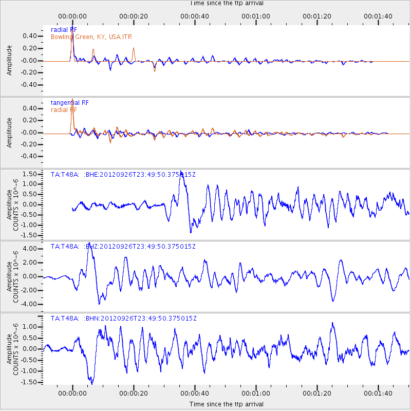
Earthquake location: Andreanof Islands, Aleutian Is.
Earthquake latitude/longitude: 51.6/-178.3
Earthquake time(UTC): 2012/09/26 (270) 23:39:55 GMT
Earthquake Depth: 16 km
Earthquake Magnitude: 6.3 MB, 6.5 MS, 6.4 MW, 6.4 MW
Earthquake Catalog/Contributor: WHDF/NEIC
Network: TA USArray Transportable Network (new EarthScope stations)
Station: T48A Bowling Green, KY, USA
Lat/Lon: 37.11 N/86.39 W
Elevation: 218 m
Distance: 63.1 deg
Az: 63.665 deg
Baz: 315.626 deg
Ray Param: 0.05980623
Estimated Moho Depth: 26.25 km
Estimated Crust Vp/Vs: 1.60
Assumed Crust Vp: 6.444 km/s
Estimated Crust Vs: 4.027 km/s
Estimated Crust Poisson's Ratio: 0.18
Radial Match: 96.55012 %
Radial Bump: 252
Transverse Match: 84.51757 %
Transverse Bump: 400
SOD ConfigId: 478790
Insert Time: 2013-02-22 23:38:35.955 +0000
GWidth: 2.5
Max Bumps: 400
Tol: 0.001

Signal To Noise

ChannelStoNSTALTA
TA:T48A: :BHZ:20120926T23:49:50.375015Z10.4682221.0057481E-69.607631E-8
TA:T48A: :BHN:20120926T23:49:50.375015Z3.6139823.1557704E-78.732114E-8
TA:T48A: :BHE:20120926T23:49:50.375015Z3.4625933.7583283E-71.0854086E-7
Arrivals
Ps2.6 SECOND
PpPs10 SECOND
PsPs/PpSs13 SECOND