You are here: Home > Network List > TA - USArray Transportable Network (new EarthScope stations) Stations List
> Station S46A Don Dixon Farm, Corydon, KY, USA > Earthquake Result Viewer
S46A Don Dixon Farm, Corydon, KY, USA - Earthquake Result Viewer
| Earthquake location: |
Andreanof Islands, Aleutian Is. |
| Earthquake latitude/longitude: |
51.6/-178.3 |
| Earthquake time(UTC): |
2012/09/26 (270) 23:39:55 GMT |
| Earthquake Depth: |
16 km |
| Earthquake Magnitude: |
6.3 MB, 6.5 MS, 6.4 MW, 6.4 MW |
| Earthquake Catalog/Contributor: |
WHDF/NEIC |
|
| Network: |
TA USArray Transportable Network (new EarthScope stations) |
| Station: |
S46A Don Dixon Farm, Corydon, KY, USA |
| Lat/Lon: |
37.68 N/87.72 W |
| Elevation: |
125 m |
|
| Distance: |
61.9 deg |
| Az: |
64.053 deg |
| Baz: |
315.006 deg |
| Ray Param: |
0.06055756 |
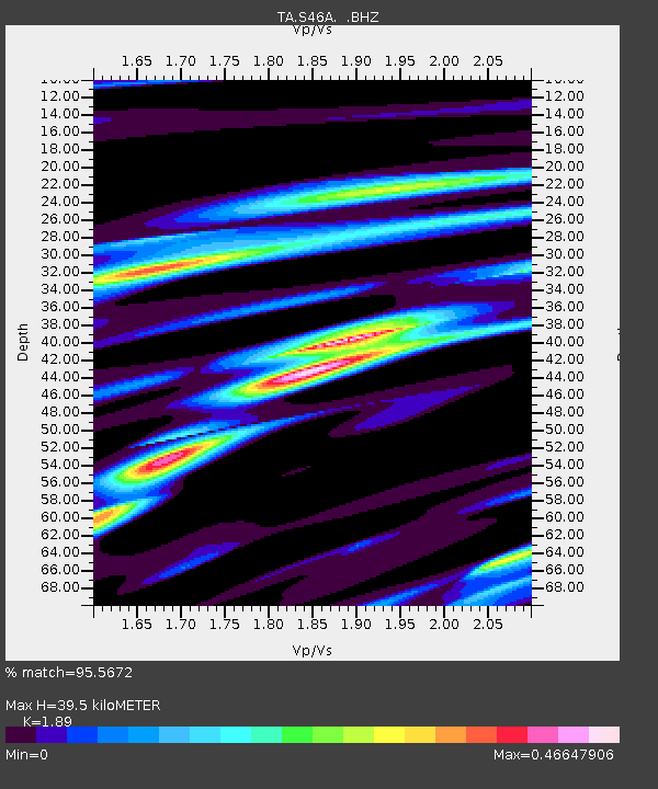
| Estimated Moho Depth: |
39.5 km |
| Estimated Crust Vp/Vs: |
1.89 |
| Assumed Crust Vp: |
6.444 km/s |
| Estimated Crust Vs: |
3.409 km/s |
| Estimated Crust Poisson's Ratio: |
0.31 |
|
| Radial Match: |
95.5672 % |
| Radial Bump: |
217 |
| Transverse Match: |
82.810104 % |
| Transverse Bump: |
400 |
| SOD ConfigId: |
478790 |
| Insert Time: |
2013-02-22 23:38:59.734 +0000 |
| GWidth: |
2.5 |
| Max Bumps: |
400 |
| Tol: |
0.001 |
|

Signal To Noise
| Channel | StoN | STA | LTA |
| TA:S46A: :BHZ:20120926T23:49:42.72499Z | 12.642752 | 1.5092658E-6 | 1.1937794E-7 |
| TA:S46A: :BHN:20120926T23:49:42.72499Z | 3.7376118 | 4.0359365E-7 | 1.079817E-7 |
| TA:S46A: :BHE:20120926T23:49:42.72499Z | 4.138205 | 5.3661097E-7 | 1.296724E-7 |
| Arrivals |
| Ps | 5.7 SECOND |
| PpPs | 17 SECOND |
| PsPs/PpSs | 23 SECOND |


