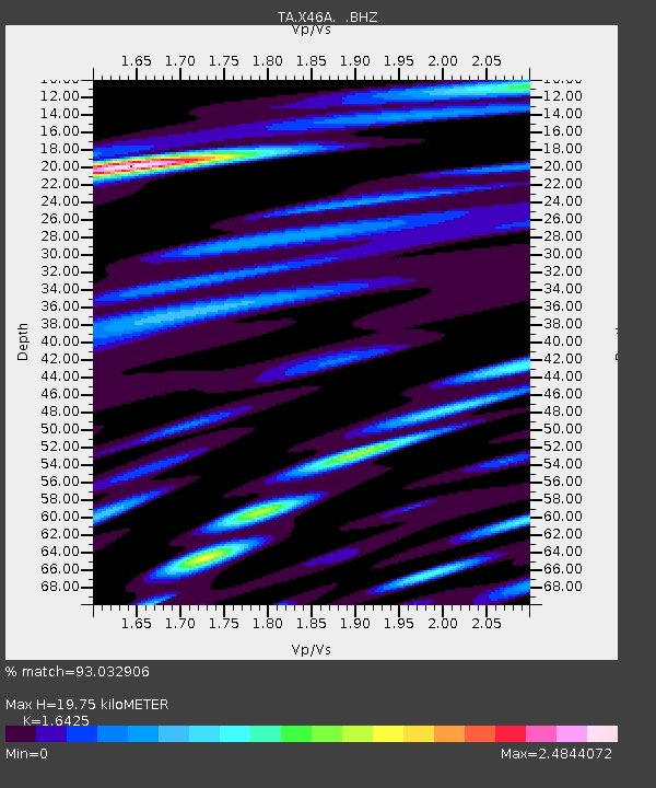
X46A Booneville, MS, USA - Earthquake Result Viewer

Earthquake location: Andreanof Islands, Aleutian Is.
Earthquake latitude/longitude: 51.6/-178.3
Earthquake time(UTC): 2012/09/26 (270) 23:39:55 GMT
Earthquake Depth: 16 km
Earthquake Magnitude: 6.3 MB, 6.5 MS, 6.4 MW, 6.4 MW
Earthquake Catalog/Contributor: WHDF/NEIC
Network: TA USArray Transportable Network (new EarthScope stations)
Station: X46A Booneville, MS, USA
Lat/Lon: 34.56 N/88.58 W
Elevation: 150 m
Distance: 63.6 deg
Az: 67.08 deg
Baz: 315.88 deg
Ray Param: 0.059428807
Estimated Moho Depth: 19.75 km
Estimated Crust Vp/Vs: 1.64
Assumed Crust Vp: 6.38 km/s
Estimated Crust Vs: 3.885 km/s
Estimated Crust Poisson's Ratio: 0.21
Radial Match: 93.032906 %
Radial Bump: 400
Transverse Match: 82.06354 %
Transverse Bump: 400
SOD ConfigId: 478790
Insert Time: 2013-02-22 23:39:26.971 +0000
GWidth: 2.5
Max Bumps: 400
Tol: 0.001

Signal To Noise

ChannelStoNSTALTA
TA:X46A: :BHZ:20120926T23:49:54.22499Z13.3188441.8811727E-61.4124144E-7
TA:X46A: :BHN:20120926T23:49:54.22499Z5.25360167.865425E-71.4971491E-7
TA:X46A: :BHE:20120926T23:49:54.22499Z6.8159649.2794954E-71.3614356E-7
Arrivals
Ps2.1 SECOND
PpPs7.8 SECOND
PsPs/PpSs9.9 SECOND