You are here: Home > Network List > TA - USArray Transportable Network (new EarthScope stations) Stations List
> Station U48A Cassie Pea, Portland, TN, USA > Earthquake Result Viewer
U48A Cassie Pea, Portland, TN, USA - Earthquake Result Viewer

| Earthquake location: |
Andreanof Islands, Aleutian Is. |
| Earthquake latitude/longitude: |
51.6/-178.3 |
| Earthquake time(UTC): |
2012/09/26 (270) 23:39:55 GMT |
| Earthquake Depth: |
16 km |
| Earthquake Magnitude: |
6.3 MB, 6.5 MS, 6.4 MW, 6.4 MW |
| Earthquake Catalog/Contributor: |
WHDF/NEIC |
|
| Network: |
TA USArray Transportable Network (new EarthScope stations) |
| Station: |
U48A Cassie Pea, Portland, TN, USA |
| Lat/Lon: |
36.51 N/86.54 W |
| Elevation: |
268 m |
|
| Distance: |
63.4 deg |
| Az: |
64.226 deg |
| Baz: |
315.791 deg |
| Ray Param: |
0.05958227 |
| Estimated Moho Depth: |
65.75 km |
| Estimated Crust Vp/Vs: |
1.75 |
| Assumed Crust Vp: |
6.444 km/s |
| Estimated Crust Vs: |
3.687 km/s |
| Estimated Crust Poisson's Ratio: |
0.26 |
|
| Radial Match: |
93.87804 % |
| Radial Bump: |
276 |
| Transverse Match: |
73.87128 % |
| Transverse Bump: |
400 |
| SOD ConfigId: |
478790 |
| Insert Time: |
2013-02-22 23:39:38.971 +0000 |
| GWidth: |
2.5 |
| Max Bumps: |
400 |
| Tol: |
0.001 |
|
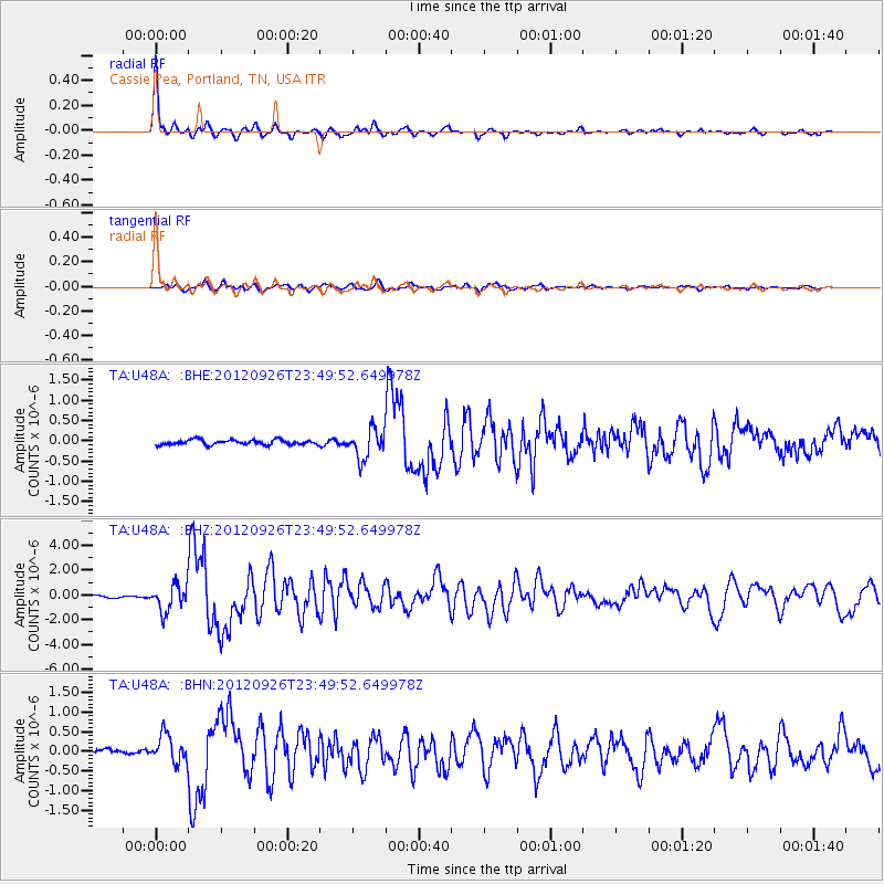
Signal To Noise
| Channel | StoN | STA | LTA |
| TA:U48A: :BHZ:20120926T23:49:52.649978Z | 12.009062 | 1.0769578E-6 | 8.967877E-8 |
| TA:U48A: :BHN:20120926T23:49:52.649978Z | 2.9593375 | 3.4945307E-7 | 1.180849E-7 |
| TA:U48A: :BHE:20120926T23:49:52.649978Z | 5.876757 | 3.5814048E-7 | 6.094186E-8 |
| Arrivals |
| Ps | 8.0 SECOND |
| PpPs | 27 SECOND |
| PsPs/PpSs | 35 SECOND |


