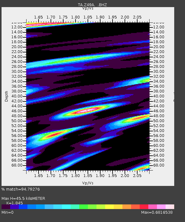
Z49A Columbiana, AL, USA - Earthquake Result Viewer
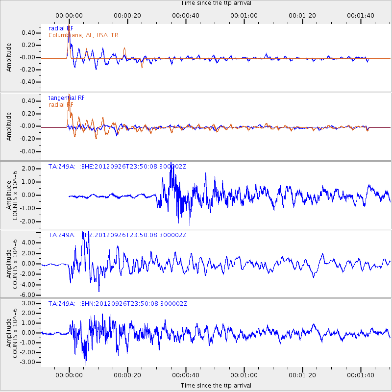
Earthquake location: Andreanof Islands, Aleutian Is.
Earthquake latitude/longitude: 51.6/-178.3
Earthquake time(UTC): 2012/09/26 (270) 23:39:55 GMT
Earthquake Depth: 16 km
Earthquake Magnitude: 6.3 MB, 6.5 MS, 6.4 MW, 6.4 MW
Earthquake Catalog/Contributor: WHDF/NEIC
Network: TA USArray Transportable Network (new EarthScope stations)
Station: Z49A Columbiana, AL, USA
Lat/Lon: 33.19 N/86.53 W
Elevation: 134 m
Distance: 65.8 deg
Az: 66.749 deg
Baz: 316.878 deg
Ray Param: 0.058015503
Estimated Moho Depth: 45.5 km
Estimated Crust Vp/Vs: 1.85
Assumed Crust Vp: 6.565 km/s
Estimated Crust Vs: 3.558 km/s
Estimated Crust Poisson's Ratio: 0.29
Radial Match: 94.79276 %
Radial Bump: 400
Transverse Match: 76.905334 %
Transverse Bump: 400
SOD ConfigId: 478790
Insert Time: 2013-02-22 23:40:37.344 +0000
GWidth: 2.5
Max Bumps: 400
Tol: 0.001

Signal To Noise

ChannelStoNSTALTA
TA:Z49A: :BHZ:20120926T23:50:08.300002Z15.4774172.1987746E-61.420634E-7
TA:Z49A: :BHN:20120926T23:50:08.300002Z6.89967547.503957E-71.0875812E-7
TA:Z49A: :BHE:20120926T23:50:08.300002Z8.30048756.302756E-77.593236E-8
Arrivals
Ps6.1 SECOND
PpPs19 SECOND
PsPs/PpSs25 SECOND