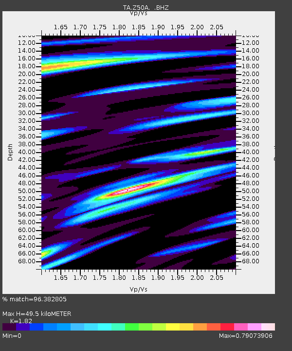
Z50A Ashland, AL, USA - Earthquake Result Viewer

Earthquake location: Andreanof Islands, Aleutian Is.
Earthquake latitude/longitude: 51.6/-178.3
Earthquake time(UTC): 2012/09/26 (270) 23:39:55 GMT
Earthquake Depth: 16 km
Earthquake Magnitude: 6.3 MB, 6.5 MS, 6.4 MW, 6.4 MW
Earthquake Catalog/Contributor: WHDF/NEIC
Network: TA USArray Transportable Network (new EarthScope stations)
Station: Z50A Ashland, AL, USA
Lat/Lon: 33.25 N/85.92 W
Elevation: 370 m
Distance: 66.1 deg
Az: 66.296 deg
Baz: 317.026 deg
Ray Param: 0.057816006
Estimated Moho Depth: 49.5 km
Estimated Crust Vp/Vs: 1.82
Assumed Crust Vp: 6.719 km/s
Estimated Crust Vs: 3.692 km/s
Estimated Crust Poisson's Ratio: 0.28
Radial Match: 96.382805 %
Radial Bump: 370
Transverse Match: 79.20133 %
Transverse Bump: 400
SOD ConfigId: 478790
Insert Time: 2013-02-22 23:40:50.512 +0000
GWidth: 2.5
Max Bumps: 400
Tol: 0.001

Signal To Noise

ChannelStoNSTALTA
TA:Z50A: :BHZ:20120926T23:50:10.250015Z26.829012.273851E-68.475344E-8
TA:Z50A: :BHN:20120926T23:50:10.250015Z14.3289547.988616E-75.5751567E-8
TA:Z50A: :BHE:20120926T23:50:10.250015Z6.62082775.6044155E-78.4648256E-8
Arrivals
Ps6.3 SECOND
PpPs20 SECOND
PsPs/PpSs26 SECOND