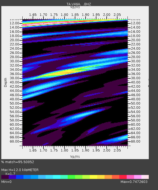
V46A Holladay, TN, USA - Earthquake Result Viewer
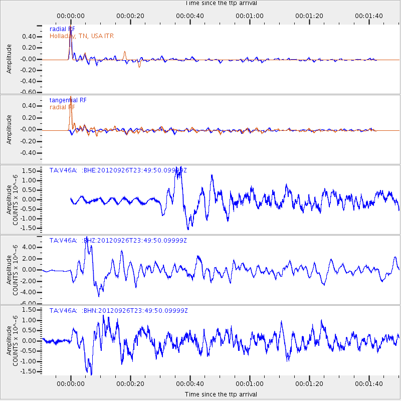
Earthquake location: Andreanof Islands, Aleutian Is.
Earthquake latitude/longitude: 51.6/-178.3
Earthquake time(UTC): 2012/09/26 (270) 23:39:55 GMT
Earthquake Depth: 16 km
Earthquake Magnitude: 6.3 MB, 6.5 MS, 6.4 MW, 6.4 MW
Earthquake Catalog/Contributor: WHDF/NEIC
Network: TA USArray Transportable Network (new EarthScope stations)
Station: V46A Holladay, TN, USA
Lat/Lon: 35.80 N/88.12 W
Elevation: 162 m
Distance: 63.0 deg
Az: 65.804 deg
Baz: 315.575 deg
Ray Param: 0.059831515
Estimated Moho Depth: 12.0 km
Estimated Crust Vp/Vs: 1.70
Assumed Crust Vp: 6.38 km/s
Estimated Crust Vs: 3.753 km/s
Estimated Crust Poisson's Ratio: 0.24
Radial Match: 95.50852 %
Radial Bump: 346
Transverse Match: 83.845215 %
Transverse Bump: 400
SOD ConfigId: 478790
Insert Time: 2013-02-22 23:41:03.123 +0000
GWidth: 2.5
Max Bumps: 400
Tol: 0.001

Signal To Noise

ChannelStoNSTALTA
TA:V46A: :BHZ:20120926T23:49:50.09999Z12.248931.220426E-69.9635315E-8
TA:V46A: :BHN:20120926T23:49:50.09999Z3.03367073.375361E-71.1126327E-7
TA:V46A: :BHE:20120926T23:49:50.09999Z4.03915074.3084142E-71.06666334E-7
Arrivals
Ps1.4 SECOND
PpPs4.9 SECOND
PsPs/PpSs6.2 SECOND