You are here: Home > Network List > G - GEOSCOPE Stations List
> Station WUS Wushi, Xinjiang Uygur, China > Earthquake Result Viewer
WUS Wushi, Xinjiang Uygur, China - Earthquake Result Viewer
| Earthquake location: |
New Britain Region, P.N.G. |
| Earthquake latitude/longitude: |
-5.3/152.6 |
| Earthquake time(UTC): |
1992/10/23 (297) 13:04:41 GMT |
| Earthquake Depth: |
33 km |
| Earthquake Magnitude: |
5.6 MB, 6.6 MS, 7.0 UNKNOWN |
| Earthquake Catalog/Contributor: |
WHDF/NEIC |
|
| Network: |
G GEOSCOPE |
| Station: |
WUS Wushi, Xinjiang Uygur, China |
| Lat/Lon: |
41.20 N/79.22 E |
| Elevation: |
1457 m |
|
| Distance: |
81.1 deg |
| Az: |
312.959 deg |
| Baz: |
105.053 deg |
| Ray Param: |
0.04776693 |
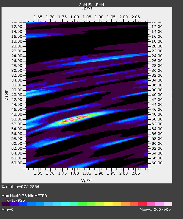
| Estimated Moho Depth: |
49.75 km |
| Estimated Crust Vp/Vs: |
1.79 |
| Assumed Crust Vp: |
6.353 km/s |
| Estimated Crust Vs: |
3.544 km/s |
| Estimated Crust Poisson's Ratio: |
0.27 |
|
| Radial Match: |
97.12866 % |
| Radial Bump: |
367 |
| Transverse Match: |
80.647224 % |
| Transverse Bump: |
400 |
| SOD ConfigId: |
16938 |
| Insert Time: |
2010-02-27 00:49:56.944 +0000 |
| GWidth: |
2.5 |
| Max Bumps: |
400 |
| Tol: |
0.001 |
|

Signal To Noise
| Channel | StoN | STA | LTA |
| G:WUS: :BHN:19921023T13:16:22.000024Z | 0.9747045 | 8.903091E-8 | 9.1341434E-8 |
| G:WUS: :BHE:19921023T13:16:22.000024Z | 3.124122 | 2.3592149E-7 | 7.55161E-8 |
| G:WUS: :BHZ:19921023T13:16:22.000024Z | 9.106694 | 5.8745763E-7 | 6.450833E-8 |
| Arrivals |
| Ps | 6.4 SECOND |
| PpPs | 21 SECOND |
| PsPs/PpSs | 28 SECOND |


