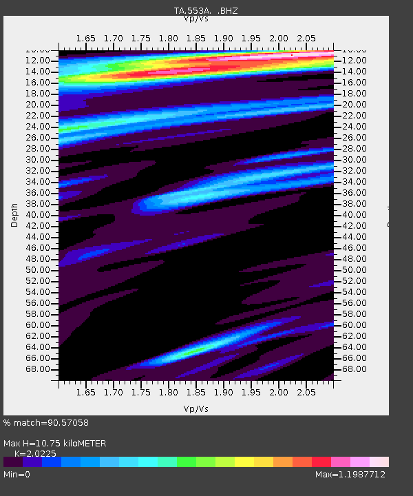
553A Crawfordville, FL, USA - Earthquake Result Viewer

Earthquake location: Andreanof Islands, Aleutian Is.
Earthquake latitude/longitude: 51.6/-178.3
Earthquake time(UTC): 2012/09/26 (270) 23:39:55 GMT
Earthquake Depth: 16 km
Earthquake Magnitude: 6.3 MB, 6.5 MS, 6.4 MW, 6.4 MW
Earthquake Catalog/Contributor: WHDF/NEIC
Network: TA USArray Transportable Network (new EarthScope stations)
Station: 553A Crawfordville, FL, USA
Lat/Lon: 30.19 N/84.43 W
Elevation: 16 m
Distance: 69.2 deg
Az: 67.506 deg
Baz: 318.266 deg
Ray Param: 0.055774577
Estimated Moho Depth: 10.75 km
Estimated Crust Vp/Vs: 2.02
Assumed Crust Vp: 6.347 km/s
Estimated Crust Vs: 3.138 km/s
Estimated Crust Poisson's Ratio: 0.34
Radial Match: 90.57058 %
Radial Bump: 400
Transverse Match: 84.77972 %
Transverse Bump: 400
SOD ConfigId: 478790
Insert Time: 2013-02-22 23:43:15.702 +0000
GWidth: 2.5
Max Bumps: 400
Tol: 0.001

Signal To Noise

ChannelStoNSTALTA
TA:553A: :BHZ:20120926T23:50:29.84999Z9.3033212.3850712E-62.5636774E-7
TA:553A: :BHN:20120926T23:50:29.84999Z2.57236085.1985563E-72.0209282E-7
TA:553A: :BHE:20120926T23:50:29.84999Z1.57119875.269775E-73.353984E-7
Arrivals
Ps1.8 SECOND
PpPs5.0 SECOND
PsPs/PpSs6.7 SECOND