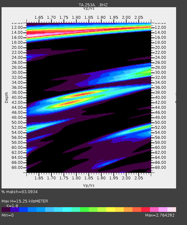
253A Americus, GA, USA - Earthquake Result Viewer

Earthquake location: Andreanof Islands, Aleutian Is.
Earthquake latitude/longitude: 51.6/-178.3
Earthquake time(UTC): 2012/09/26 (270) 23:39:55 GMT
Earthquake Depth: 16 km
Earthquake Magnitude: 6.3 MB, 6.5 MS, 6.4 MW, 6.4 MW
Earthquake Catalog/Contributor: WHDF/NEIC
Network: TA USArray Transportable Network (new EarthScope stations)
Station: 253A Americus, GA, USA
Lat/Lon: 32.06 N/84.13 W
Elevation: 136 m
Distance: 68.0 deg
Az: 65.96 deg
Baz: 317.858 deg
Ray Param: 0.056569554
Estimated Moho Depth: 15.25 km
Estimated Crust Vp/Vs: 1.60
Assumed Crust Vp: 6.719 km/s
Estimated Crust Vs: 4.2 km/s
Estimated Crust Poisson's Ratio: 0.18
Radial Match: 83.0934 %
Radial Bump: 400
Transverse Match: 84.05785 %
Transverse Bump: 400
SOD ConfigId: 478790
Insert Time: 2013-02-22 23:45:22.772 +0000
GWidth: 2.5
Max Bumps: 400
Tol: 0.001

Signal To Noise

ChannelStoNSTALTA
TA:253A: :BHZ:20120926T23:50:22.274978Z12.1656162.1593044E-61.774924E-7
TA:253A: :BHN:20120926T23:50:22.274978Z2.88547567.992227E-72.7698127E-7
TA:253A: :BHE:20120926T23:50:22.274978Z3.5128091.0431694E-62.969616E-7
Arrivals
Ps1.4 SECOND
PpPs5.6 SECOND
PsPs/PpSs7.1 SECOND