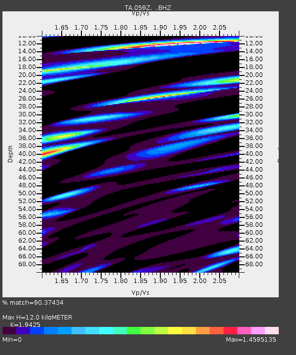
059Z Ave Maria, FL, USA - Earthquake Result Viewer
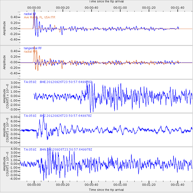
Earthquake location: Andreanof Islands, Aleutian Is.
Earthquake latitude/longitude: 51.6/-178.3
Earthquake time(UTC): 2012/09/26 (270) 23:39:55 GMT
Earthquake Depth: 16 km
Earthquake Magnitude: 6.3 MB, 6.5 MS, 6.4 MW, 6.4 MW
Earthquake Catalog/Contributor: WHDF/NEIC
Network: TA USArray Transportable Network (new EarthScope stations)
Station: 059Z Ave Maria, FL, USA
Lat/Lon: 26.34 N/81.44 W
Elevation: 8.0 m
Distance: 73.9 deg
Az: 68.057 deg
Baz: 319.849 deg
Ray Param: 0.05271475
Estimated Moho Depth: 12.0 km
Estimated Crust Vp/Vs: 1.94
Assumed Crust Vp: 6.347 km/s
Estimated Crust Vs: 3.267 km/s
Estimated Crust Poisson's Ratio: 0.32
Radial Match: 90.37434 %
Radial Bump: 400
Transverse Match: 71.60276 %
Transverse Bump: 400
SOD ConfigId: 478790
Insert Time: 2013-02-22 23:45:50.489 +0000
GWidth: 2.5
Max Bumps: 400
Tol: 0.001

Signal To Noise

ChannelStoNSTALTA
TA:059Z: :BHZ:20120926T23:50:57.649978Z8.9538542.5673824E-62.8673492E-7
TA:059Z: :BHN:20120926T23:50:57.649978Z1.89203867.853024E-74.150562E-7
TA:059Z: :BHE:20120926T23:50:57.649978Z1.62843556.278739E-73.8556877E-7
Arrivals
Ps1.8 SECOND
PpPs5.4 SECOND
PsPs/PpSs7.2 SECOND