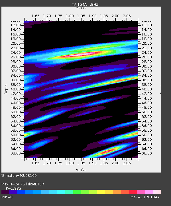
154A Montrose, GA, USA - Earthquake Result Viewer

Earthquake location: Andreanof Islands, Aleutian Is.
Earthquake latitude/longitude: 51.6/-178.3
Earthquake time(UTC): 2012/09/26 (270) 23:39:55 GMT
Earthquake Depth: 16 km
Earthquake Magnitude: 6.3 MB, 6.5 MS, 6.4 MW, 6.4 MW
Earthquake Catalog/Contributor: WHDF/NEIC
Network: TA USArray Transportable Network (new EarthScope stations)
Station: 154A Montrose, GA, USA
Lat/Lon: 32.61 N/83.11 W
Elevation: 111 m
Distance: 68.2 deg
Az: 64.87 deg
Baz: 317.996 deg
Ray Param: 0.056457456
Estimated Moho Depth: 24.75 km
Estimated Crust Vp/Vs: 1.84
Assumed Crust Vp: 6.565 km/s
Estimated Crust Vs: 3.577 km/s
Estimated Crust Poisson's Ratio: 0.29
Radial Match: 92.28109 %
Radial Bump: 400
Transverse Match: 81.75248 %
Transverse Bump: 400
SOD ConfigId: 478790
Insert Time: 2013-02-22 23:46:47.821 +0000
GWidth: 2.5
Max Bumps: 400
Tol: 0.001

Signal To Noise

ChannelStoNSTALTA
TA:154A: :BHZ:20120926T23:50:23.34999Z15.9043832.033201E-61.2783904E-7
TA:154A: :BHN:20120926T23:50:23.34999Z5.20061739.648405E-71.8552424E-7
TA:154A: :BHE:20120926T23:50:23.34999Z3.8890118.306728E-72.1359487E-7
Arrivals
Ps3.3 SECOND
PpPs10 SECOND
PsPs/PpSs14 SECOND