You are here: Home > Network List > TA - USArray Transportable Network (new EarthScope stations) Stations List
> Station 255A Hazlehurst, GA, USA > Earthquake Result Viewer
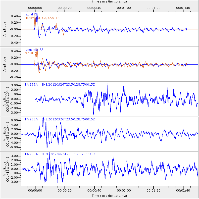
255A Hazlehurst, GA, USA - Earthquake Result Viewer
*The percent match for this event was below the threshold and hence no stack was calculated.
| Earthquake location: |
Andreanof Islands, Aleutian Is. |
| Earthquake latitude/longitude: |
51.6/-178.3 |
| Earthquake time(UTC): |
2012/09/26 (270) 23:39:55 GMT |
| Earthquake Depth: |
16 km |
| Earthquake Magnitude: |
6.3 MB, 6.5 MS, 6.4 MW, 6.4 MW |
| Earthquake Catalog/Contributor: |
WHDF/NEIC |
|
| Network: |
TA USArray Transportable Network (new EarthScope stations) |
| Station: |
255A Hazlehurst, GA, USA |
| Lat/Lon: |
31.93 N/82.48 W |
| Elevation: |
45 m |
|
| Distance: |
69.1 deg |
| Az: |
64.933 deg |
| Baz: |
318.354 deg |
| Ray Param: |
$rayparam |
*The percent match for this event was below the threshold and hence was not used in the summary stack. |
|
| Radial Match: |
89.63144 % |
| Radial Bump: |
394 |
| Transverse Match: |
82.57312 % |
| Transverse Bump: |
400 |
| SOD ConfigId: |
478790 |
| Insert Time: |
2013-02-22 23:47:02.118 +0000 |
| GWidth: |
2.5 |
| Max Bumps: |
400 |
| Tol: |
0.001 |
|
Signal To Noise
| Channel | StoN | STA | LTA |
| TA:255A: :BHZ:20120926T23:50:28.750015Z | 7.356975 | 1.7790279E-6 | 2.4181512E-7 |
| TA:255A: :BHN:20120926T23:50:28.750015Z | 2.8272088 | 9.3346534E-7 | 3.3017207E-7 |
| TA:255A: :BHE:20120926T23:50:28.750015Z | 2.5795584 | 8.6438996E-7 | 3.3509224E-7 |
| Arrivals |
| Ps | |
| PpPs | |
| PsPs/PpSs | |


