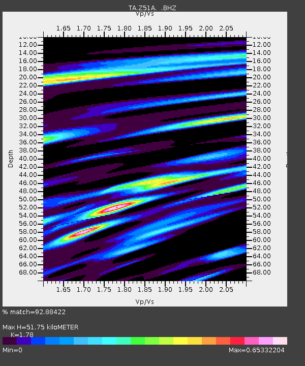
Z51A Franklin, GA, USA - Earthquake Result Viewer
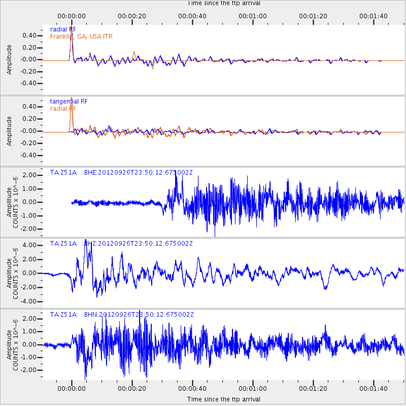
Earthquake location: Andreanof Islands, Aleutian Is.
Earthquake latitude/longitude: 51.6/-178.3
Earthquake time(UTC): 2012/09/26 (270) 23:39:55 GMT
Earthquake Depth: 16 km
Earthquake Magnitude: 6.3 MB, 6.5 MS, 6.4 MW, 6.4 MW
Earthquake Catalog/Contributor: WHDF/NEIC
Network: TA USArray Transportable Network (new EarthScope stations)
Station: Z51A Franklin, GA, USA
Lat/Lon: 33.32 N/85.17 W
Elevation: 249 m
Distance: 66.5 deg
Az: 65.749 deg
Baz: 317.214 deg
Ray Param: 0.057566956
Estimated Moho Depth: 51.75 km
Estimated Crust Vp/Vs: 1.78
Assumed Crust Vp: 6.719 km/s
Estimated Crust Vs: 3.775 km/s
Estimated Crust Poisson's Ratio: 0.27
Radial Match: 92.88422 %
Radial Bump: 400
Transverse Match: 81.32114 %
Transverse Bump: 400
SOD ConfigId: 478790
Insert Time: 2013-02-22 23:47:43.784 +0000
GWidth: 2.5
Max Bumps: 400
Tol: 0.001

Signal To Noise

ChannelStoNSTALTA
TA:Z51A: :BHZ:20120926T23:50:12.675002Z17.2350231.9120853E-61.1094185E-7
TA:Z51A: :BHN:20120926T23:50:12.675002Z10.337688.076434E-77.812618E-8
TA:Z51A: :BHE:20120926T23:50:12.675002Z7.1373026.8078305E-79.5383804E-8
Arrivals
Ps6.3 SECOND
PpPs20 SECOND
PsPs/PpSs27 SECOND