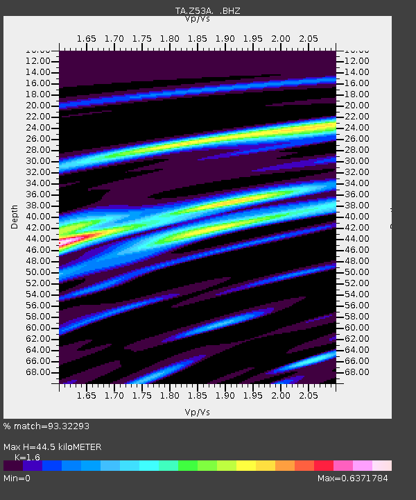
Z53A Monticello, GA, USA - Earthquake Result Viewer

Earthquake location: Andreanof Islands, Aleutian Is.
Earthquake latitude/longitude: 51.6/-178.3
Earthquake time(UTC): 2012/09/26 (270) 23:39:55 GMT
Earthquake Depth: 16 km
Earthquake Magnitude: 6.3 MB, 6.5 MS, 6.4 MW, 6.4 MW
Earthquake Catalog/Contributor: WHDF/NEIC
Network: TA USArray Transportable Network (new EarthScope stations)
Station: Z53A Monticello, GA, USA
Lat/Lon: 33.28 N/83.57 W
Elevation: 144 m
Distance: 67.4 deg
Az: 64.7 deg
Baz: 317.68 deg
Ray Param: 0.056949876
Estimated Moho Depth: 44.5 km
Estimated Crust Vp/Vs: 1.60
Assumed Crust Vp: 6.565 km/s
Estimated Crust Vs: 4.103 km/s
Estimated Crust Poisson's Ratio: 0.18
Radial Match: 93.32293 %
Radial Bump: 376
Transverse Match: 76.41022 %
Transverse Bump: 400
SOD ConfigId: 478790
Insert Time: 2013-02-22 23:47:56.296 +0000
GWidth: 2.5
Max Bumps: 400
Tol: 0.001

Signal To Noise

ChannelStoNSTALTA
TA:Z53A: :BHZ:20120926T23:50:18.59999Z13.2389581.645275E-61.2427526E-7
TA:Z53A: :BHN:20120926T23:50:18.59999Z11.3831569.897801E-78.695129E-8
TA:Z53A: :BHE:20120926T23:50:18.59999Z12.937811.0430823E-68.062279E-8
Arrivals
Ps4.3 SECOND
PpPs17 SECOND
PsPs/PpSs21 SECOND