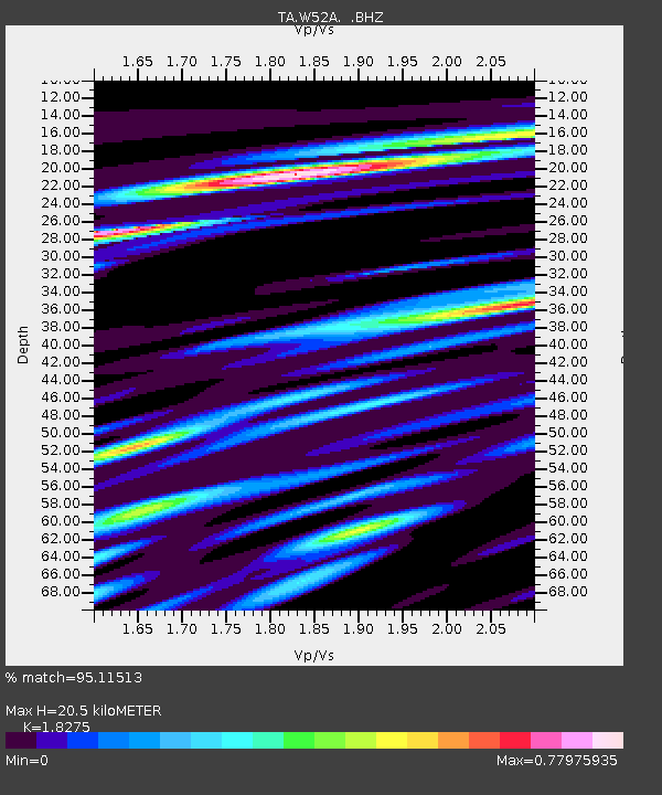
W52A Murphy, NC, USA - Earthquake Result Viewer
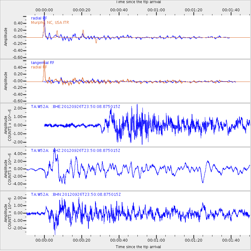
Earthquake location: Andreanof Islands, Aleutian Is.
Earthquake latitude/longitude: 51.6/-178.3
Earthquake time(UTC): 2012/09/26 (270) 23:39:55 GMT
Earthquake Depth: 16 km
Earthquake Magnitude: 6.3 MB, 6.5 MS, 6.4 MW, 6.4 MW
Earthquake Catalog/Contributor: WHDF/NEIC
Network: TA USArray Transportable Network (new EarthScope stations)
Station: W52A Murphy, NC, USA
Lat/Lon: 35.09 N/83.93 W
Elevation: 519 m
Distance: 65.9 deg
Az: 63.603 deg
Baz: 317.046 deg
Ray Param: 0.05795693
Estimated Moho Depth: 20.5 km
Estimated Crust Vp/Vs: 1.83
Assumed Crust Vp: 6.35 km/s
Estimated Crust Vs: 3.475 km/s
Estimated Crust Poisson's Ratio: 0.29
Radial Match: 95.11513 %
Radial Bump: 330
Transverse Match: 82.06722 %
Transverse Bump: 400
SOD ConfigId: 478790
Insert Time: 2013-02-22 23:48:12.198 +0000
GWidth: 2.5
Max Bumps: 400
Tol: 0.001

Signal To Noise

ChannelStoNSTALTA
TA:W52A: :BHZ:20120926T23:50:08.875015Z9.3504951.1230762E-61.2010875E-7
TA:W52A: :BHN:20120926T23:50:08.875015Z4.2590554.5938933E-71.0786179E-7
TA:W52A: :BHE:20120926T23:50:08.875015Z4.6239984.6283742E-71.0009463E-7
Arrivals
Ps2.8 SECOND
PpPs8.8 SECOND
PsPs/PpSs12 SECOND